

 Historical Tour Guide
A Suspension Bridge in Cleveland

Summary

Summary
For at least 25 years, I have been intrigued by a run-down, abandoned bridge – compelled finally to do something to save it because I see it as distinctive in its beauty, its rarity in being a suspension footbridge, its ties with the racial tension which helped to shut it down and other fascinating elements - and the emotional resonance of its being in what is at least symbolically my hometown – Cleveland, Ohio. It is called the Sidaway Avenue Suspension Bridge, was built in 1930, and can be seen in some of its deterioration and past youth here: http://www.google.com/search?hl=en&sugexp=gsis,i18n%3Dtrue&cp=32&gs_id=3&xhr=t&q=Sidaway+Avenue+Suspension+Bridge&qe=U2lkYXdheSBBdmVudWUgU3VzcGVuc2lvbiBCcmlkZ2U&qesig=M8dxBT7HoS7dTWspvtePGw&pkc=AFgZ2tkzI4L7WgXIkAt1uXhAPTfYLblmGcU0Y9YYwbl8Adf8Ivi8-3yfXNmaVsIOQjVE8hlpFVBhpCsf6azHO7WJI0b6UKbXfw&gs_sm=&gs_upl=&bav=on.2,or.r_gc.r_pw.&biw=1024&bih=601&um=1&ie=UTF-8&tbm=isch&source=og&sa=N&tab=wi
In late August and early September of this year, I sought out both neighborhood and citywide leaders as well as residents near the bridge, with the goal of seeing what they think about the subject of the bridge’s preservation and revival, while also sharing my hopes for those outcomes. I basically found that there were, more often than not, potentially positive feelings for the bridge, the former meaning in large part that there is a great lack of awareness of it, partly because of its decades-long abandonment, but that people with a lack of awareness have at least some possibility of being open to reusing this landmark, and I would hope as well that those residents and area employees who are negative to saving the bridge can, through respect for their views and a vision for its rehabilitation, be partly won over to its saving and resurgence.
At the same time, the neighborhoods on either side of the bridge have both had socioeconomic and physical “ups” in recent decades, but are still very much caught in a challenging context of poverty, home foreclosures and other urban ills and the cause of the Sidaway Bridge’s preservation is one whose flame may be “back burner” for some time to come. In addition, the bridge’s “ups” have virtually all been in cyber-space or other appreciative forums such as this one, while its decline has presumably progressed, so that its timely stabilization may be the best option, and a full investigation of its physical status may be potentially critical right now.
Besides seeing worth in the presentation below, I also try to honestly present its limitations, depending on one’s viewpoint. One, for detailed historians, may be the impressionistic and qualified nature of some of my findings, and feelings may be similar to the extent you value rigorous and exacting sociological study. The second case overlaps with my biases and how they may have influenced my interviews, as covered in Appendix 1.
I hope that articles such as this one help keep on at least a pilot light for the Bridge’s rebirth and offer a good balance between valuing views of residents and leaders as well as strengthening the message of preserving heritage, hometown and otherwise.
Josh Silver
“Housekeeping” – simplifying this article
Not surprisingly, I hope that as many readers as possible will read everything I’ve written here, from “Z” to “Appendices”, so to speak, and that it has some positive social impact, but I would gladly trade full readings for more social impact, or, rather, recommend the summary above and “Viewpoints on the Bridge”, below - minus my footnotes - as my key segments.
I have tried in this piece to “bridge” the worlds of laypeople and serious urban professionals, as well as the informality of a blog and more serious research.
Technical matters
As of this paper’s completion, the author’s nails are figuratively smaller due to problems, however minor, thankfully, with a small number of disappearing pictures herein, so I have prepared a site on my blog, at http://silverstravels.blogspot.com/ titled “A Suspension Bridge in Cleveland - Pics and Captions” whose representative sample of my photos from late August should be an insurance for any potential gaps here.
Introduction
Glossary
I hope that this article will be especially read by people with a desire to save and revive the heritage of Cleveland, Ohio but since it will hopefully also be read by others outside of the Cleveland area, here is a glossary of a few of the terms used herein, mostly “local” in nature, with the caveat that, overall, it may be the most boring possible such list for people who live in the Cleveland-area [as I once did (!)], but a few of its terms – asterisked (***) – may be of greater interest and/or usefulness to readers whatever their community….
***“bridge area” – my term and not used by others, at least in my discussions
***Bridgeport – used at least for a small shopping/community development, “Bridgeport Place”, pictured here, located near the northeast corner of East 72nd Street and Kinsman Avenue and perhaps of value in promoting the starring landmark of this article at some point
Burten, Bell, Carr Development, Incorporated (or “BBC”) – see “CDC”
CDC - “community development corporation”, with at least two sizeable ones in the “bridge area” – Burten, Bell, Carr Development, Incorporated, serving an area partly to the north of the bridge, and Slavic Village Development, focusing on an area partly to the south of it
CMHA – Cuyahoga Metropolitan Housing Authority; the public housing provider in Cuyahoga County, Ohio (which includes the City of Cleveland), since 1933
CWRU – Case Western Reserve University
Downtown, downtown – Downtown Cleveland
East side, east side – east side of the city of Cleveland
Garden Valley Homes – a CMHA development started in the late 1950’s in Kinsman (see below) and more recently being phased out for replacement by a housing complex known as Heritage View; one of its properties is seen here at the southwest corner of 79th and Kinsman:


Kingsbury Run – once a free-flowing creek which has since been culverted and is far from
the bucolic days in which it was named for James Kingsbury, an early New England immigrant to Cleveland, with its immediate environs long since housing train tracks, industry and the site of what may be Cleveland’s most notorious murders – named for the creek or known as the “torso” murders, and part of the mystique of Elliott Ness, who following his Chicago days with the “Untouchables” oversaw the investigation into these serial killings as Cleveland’s Director of Public Safety from 1935-42, but where a continuing lack of resolution may have frustrated and followed Ness to his death.[i]
Kinsman – a Southeast Cleveland neighborhood located partly north of the bridge and named after a major East Side street which passes through it
***Rapid/”the Rapid” – a public transit train connecting the east and west sides of the City of Cleveland, operated by RTA (see below) and, I would bet, the main way that most people have seen the bridge, which is just BARELY visible here, if from the adjacent “Shaker Rapid” tracks (see entry below):

If you wish to try the “detection” game, which would probably include your ability to blow up this image…below the middle of the picture are four poles which look like they have triangular attachments; above the first and second ones from the left, I’ll hope that you can barely see the top of the bridge’s north pier, and above the second and the third ones from the left, you should be able to dimly see a mid-section of the bridge, looking as if it is floating in air. [My views of the bridge have usually been much more obvious, if without the glorious rise of a 1978 photo visible here: http://memory.loc.gov/cgi-bin/displayPhoto.pl?path=/pnp/habshaer/oh/oh0000/oh0010/photos&topImages=125747pr.jpg&topLinks=125747pv.jpg,125747pu.tif&title=3.%20%20General%20view%20looking%20north%20of%20bridge.%20Shaker%20Heights%20Rapid%20Transit%20line%20car%20barns%20visible%20in%20foreground.%20%20%20%20%20%20%20%20%20%3cbr%3eHAER%20OHIO,18-CLEV,23-3&displayProfile=0 and through the “Google” url at the beginning of my article.
Abbreviations
K-Run CCPC – summary headed “kingsbury run greenway” under “bikeway master plan” of the Cleveland City Planning Commission, at http://planning.city.cleveland.oh.us/bike/kingsbury.html]
K. Run Project -- “Kingsbury Run Greenway Project” [authored by Wilbur Smith and Associates for Slavic Village Development and Burten, Bell, Carr, no date given but likely to be 2005 based on the Cleveland City Planning Commission site below] (http://planning.city.cleveland.oh.us/cwp/other/KingsburyRunGreenwayFinal.pdf)
[i] The following sources were consulted here in regards to….
…James Kingsbury: http://ech.cwru.edu/ech-cgi/article.pl?id=KJ1 [James Kingsbury entry in the Encyclopedia of Cleveland History]
…Kingsbury Run: http://ech.cwru.edu/ech-cgi/article.pl?id=KR1 [Kingsbury Run entry from the Encyclopedia of Cleveland History] and http://planning.city.cleveland.oh.us/bike/kingsbury.html [“kingsbury run greenway” under “bikeway master plan” of the Cleveland City Planning Commission, hereinafter referred to as “K-Run CCPC”];
…the Kingsbury Run murders: http://www.deadohio.com/Kinsbury.htm [“Kingsbury Run” article in site
devoted to “Northeast Ohio’s Haunted Places, Legends and Abandoned Cemeteries”];; http://ech.cwru.edu/ech-cgi/article.pl?id=TM [“TORSO MURDERS” entry in the Encyclopedia of Cleveland History]; http://www.torsomurders.com/ [“Cleveland Torso Murders” history, FAQ’s, etc.]
…Eliot Ness: http://ifip.com/ness.html ["Eliot Ness: The Real Story"]; http://www.infoplease.com/biography/var/eliotness.html [“Eliot Ness”]; http://ech.cwru.edu/ech-cgi/article.pl?id=NE [Eliot Ness entry in the Encyclopedia of Cleveland History]; http://www.ttb.gov/student_research/eliot_ness.shtml [“Eliot Ness 1902-1957”, a biography on the website of the The Alcohol and Tobacco Tax and Trade Bureau (TTB) of the U.S. Department of the Treasury, one reason it may be the most favorable account of several seen here, and perhaps in part why it does not mention the Kingsbury Run Murders; additionally, Ness’s birthdate likely was 1903 as opposed to 1902]
***St. Hyacinth/Jackowo – old neighborhood names (the latter meaning “hyacinth” in Polish) for blocks which might be considered the most northern section of Slavic Village (below), and where I spent my late-August time south of the bridge; their namesake was St. Hyacinth Church, a largely Polish Catholic congregation whose sanctuary, seen here…

closed in recent years and has re-opened with another congregation – the Elizabeth Baptist Church – this past summer[i]
***SB – Sidaway Bridge (abbreviation which may be used herein)
***Shaker Rapid – a pair of train services on the same tracks as the “Rapid” east of downtown until just east of 55th Street when it splits off to the southeast to ultimately reach large parts of Shaker Heights, a suburb which still retains much of its early 20th-century elegance and which was given birth by locally legendary railroad magnates the Van Sweringen brothers - Oris Paxton and Mantis James, who were so intent on its receiving rapid transit that they bought a 513-mile long railroad – the “New York, Chicago & St. Louis”, also known as the Nickel Plate Railroad, so they could own the five mile stretch of Nickel Plate tracks from downtown to Shaker Heights, and among other related creations, their industry lead to the building of the Sidaway Bridge to safely transport pedestrians over Shaker Rapid rail shops, while the bridge‘s ownership went quickly to the City of Cleveland by mutual agreement with the Nickel Plate.[ii]
Slavic Village – a Southeast Cleveland neighborhood located partly south of the bridge whose name (of 70’s vintage I believe) honors the Slavic heritage of many of the residents there since the 1870’s, with a large non-Slavic-American, non-Caucasian presence there as well since the 1960’s
Slavic Village Development (or “SVD”) – see “CDC”
University Circle – a large concentration of cultural and other institutions on the East Side
[i] Please see: http://slavicvillage.org/new-face-of-faith-and-fellowship-comes-to-slavic-village for coverage by the Slavic Village Development CDC.
[ii]Historic American Engineering Record, “Sidaway Avenue Bridge”, pp. 2 & 6 (report by Carol Poh Miller, now Carol Poh, August, 1978); (subsequently referred to as “HAER”)
Geography
The map accessible below appeared from entering what has been noted as an official address for the bridge – 6686 Sidaway Avenue (while it may display the official heading of “6900-6959 Sidaway”), and it can be enlarged or focused on smaller sections going out from the arrow identifying that formal address, if you use the plus and minus bar to its upper left; clicking on the “aerial map” notation to the upper right of the map will give you a view of ground preparation for the Heritage View homes and a faint view of the bridge to the lower left of the Heritage View site:
http://classic.mapquest.com/maps?city=Cleveland&state=OH&address=%5B6900-6959%5D+Sidaway+Ave&zipcode=44104&country=US&latitude=41.480845&longitude=-81.64133&geocode=BLOCK [*** - AS OF AUG. 27, 2015, A CHANGE I WOULD NOTE IS that you can click on "Satellite" at the upper right side of the map which appears.]
More satisfyingly for the curious, and in connection with a hint in “Technical matters….” above, if you enter “6686 Sidaway Ave, Cleveland, OH 44127” at http://maps.google.com/, click on a rectangular image which appears at the left, the “bridge area” world, as of perhaps last year, should start appearing to the right side of your screen and allow you to “explore” the streets of the area, at least to the south of the bridge. [And for my technophobic soulmates - since I figured it out I’ll bet you can too!] One starting point for seeing “googlemaps” photos of streets to the north of the bridge (if pre-Heritage View) is “7100 Kinsman Road, Cleveland, OH, 44127” (chosen in lieu of private homes closer to the bridge and for the exterior J motive that this is the address for the shuttered but significant Garden Valley Neighborhood House). [8/27/15 - Not shuttered as of 8/25/15 at least:)!!]
Aims of this article
I would like this article to help to re-light the fire that has burned for some years now to save Cleveland‘s striking if deteriorated Sidaway Avenue Suspension Bridge and to light a new fire for many more people who may or may not be part of the Greater Cleveland community of historic preservationists. My main focus below will be to introduce sentiments regarding the Bridge by residents in the two neighborhoods on either side of it, and while the numbers of interviewees here are small indeed, they begin to lay out basic themes that are essential to honor and work with, assuming that a preservation effort emphasizes resident involvement.
Research for this article
The following breakdowns, however meaningful, do not recognize the complexity of all of the individuals involved, e.g., a resident living in Kinsman now, but Slavic Village formerly, or vice-versa.
38 individuals were contacted for this article, with the following results:
19 face-to-face interviews out of 28 approaches to people I met in the neighborhoods on either side of the bridge, including 5 interviews with people who work in or visit but do not reside in the “bridge neighborhoods” and one phone call with an ex-resident of the Slavic Village section;
19 e-mails to neighborhood- and city-wide leaders and/or professionals in relevant fields who are noted in appendix 2 below, with 12 responses in the form of thoughts on the Bridge and/or referrals to potential players in any preservation effort;
Alternately, not counting my phone interviewee, the contacts above added up to 13 interviews with people currently linked to Kinsman and 6 currently identifying with Slavic Village, plus approaches which did not lead to interviews to three people north of the bridge and five people south of it.
A note on my Biases
Somewhat simplistically, perhaps, I would say that my biases are of being highly pro-preservation, wanting maximum resident input in community planning and being comfortable with informal as opposed to rigorous interviewing, feeling that that translated to some balance between independent statements of beliefs from residents followed by my volunteering why I was exploring the topic., i.e., clearly wanting to save the bridge.
On another note – sensitive enough that I would highly encourage readers to see my additional comments in Appendix 1 - I feel that my sense for many years now that blacks, especially lower-income and working-class blacks, have not been as involved in historic preservation as whites, especially middle-income and upper-income whites, may have led me to the flaw of underrepresenting non-black residents in the “bridge area”, but that this is partly resolved by commonalities I began to see in residents’ views on the bridge whatever their background.
“Outsider” Sensitivity and a redux for Resident Respect
Always implicit in a study like mine are the roles and behaviors of outsiders, often, like me, suburbanites, former suburbanites now in neighborhoods and communities clearly different – socioeconomically and otherwise – from some of the neighborhoods in which they are interested. I believe my role and their role will always be criticized at times, should be criticized, constructively, and at the same time, should take place if we truly believe in the symbolic, emotional and economic importance of central cities to their regions.
Coincidentally, my late research here included discovering the case of Allan Jacobs, who grew up (at least in part) in the Cleveland area, left Ohio for graduate education at the University of Pennsylvania and obtained a master’s degree in city planning there in 1954, 39 years before I received a graduate degree in Penn’s historic preservation program.[i] Jacobs came back to Cleveland at least once - right after his graduation in Philadelphia and perhaps without my middle-aged duality of cynicism and idealism - to design the Garden Valley Homes, a project that like the Heritage View development now emerging on its site, began with high hopes, but perhaps a much higher hurdle, since much of its green space would lie above what was then an extremely polluted Kingsbury Run, whose identity at the time was more freshly defined by the “torso” murders noted earlier.
Jacobs was highly supported in his Garden Valley plan, partly under the visionary Ernest Bohn, widely considered the grandfather of CMHA as its first director, from 1933-68, and both may have been high with excitement, or at least 70 feet or more above the ground, when they initially discussed Jacobs’ plans for Garden Valley on the planks of the Sidaway Bridge in the Summer of 1954.[ii] In 1959, however, within two years of its debut, news of decline at Garden Valley emerged and would only snowball, along with intense critiques of CMHA in general by the 90’s if not earlier. Along with other factors, this deterioration led Jacobs, ultimately, to a deep belief in resident input for community planning, one of the key missing elements of not only his planning, but a widespread 50’s and 60’s urban renewal “M.O. of “top-down” designs, with no solicitation of residents’ thoughts. [Please see Appendix 3 if you remain interested in exploring the assessment of Garden Valley’s origins in the article cited here.]
Today, it is de rigeur to include residents in community improvements, as reflected, for example, in a current brochure of Burten, Bell, Carr which states, as the third of its four objectives, that it will “[e]mpower and involve residents in building the image and social fabric of our neighborhoods”. While I will not attempt to prove it as I believe full-time urban preservationists can, I believe that such consultation has in part led to a rough recreation of old streetscapes as sub-sections in the “Central” neighborhood of BBC’s service area, a contrast to what Jacobs and others came to see as the awkward and spatially alienating suburban nature of Garden Valley.[iii] Likewise, taking a section of the Slavic Village Development website, the 5th and 7th of eight “core values” of SVD - “· Community Empowerment” and a “· Sense of community ownership … through the education and empowerment of residents….” at least imply that residents will be consulted prior to redevelopments.
I believe that CMHA has also moved towards resident involvement, with one reflection here coming from Cortney Kilbury, its marketing director, noting to me that its interim CEO Jeffery Patterson has stated that Heritage View could not have been achieved without several components, starting with “resident engagement”.[iv]
[i] Additionally, it appears that we share the same high school – Cleveland Heights High - with Jacobs graduating from there in 1947, according to word of his induction into its Hall of Fame 49 years later, noted at http://www.heightsalumni.org/hof/1996.shtml.
[ii] A study I read on Garden Valley’s early history notes that Bohn and Jacobs walked through the proposed Garden Valley area and “when they were on the pedestrian suspension bridge that spanned Kingsbury Run, Bohn asked Jacobs for the plan [held] it up and said ‘Let it never be said we had our feet on the ground when we made these decisions!’” [Bradley Flamm, “The Garden Valley: Remembering Visions and Values in 1950s Cleveland with Allan Jacobs”, Berkeley Planning Journal, Volume 18, 2005, p. 111; hereinafter referred to as “Flamm ‘GV’ at http://www.ced.berkeley.edu/pubs/bpj/pdf/7_BPJ_v18_2005_Flamm_p101-118.pdf”]. Flamm however goes on to say that “[h]ad Ernest Bohn known what was in store for the Garden Valley, he would have wanted his feet to be more firmly planted on the ground that summer day 50 years ago. The high hopes and ambitions of Garden Valley’s planning may have carried over into the early years of construction and occupancy, but they did not last long.” [p. 112]
[iii]“A Beacon for a Brighter Community” (booklet), by Burten, Bell, Carr Development, Inc. [N.D., but available with other current literature when picked up at BBC offices on Aug. 29, 2011]
[iv] http://slavicvillage.org/aboutsvd [“About SVD” segment of SVD website]; E-mail from Cortney Kilbury, Sept. 8, 2011
Viewpoints on the Bridge
Introducing my own experience of the bridge
For at least 25 years, I have been intrigued by a closed and decaying bridge in Cleveland, and more so in the sense that, symbolically, at least, Cleveland is my hometown (or an adjacent suburb – Cleveland Heights – to be exact). The view which can be seen here: http://memory.loc.gov/cgi-bin/displayPhoto.pl?path=/pnp/habshaer/oh/oh0000/oh0010/photos&topImages=125747pr.jpg&topLinks=125747pv.jpg,125747pu.tif&title=3.%20%20General%20view%20looking%20north%20of%20bridge.%20Shaker%20Heights%20Rapid%20Transit%20line%20car%20barns%20visible%20in%20foreground.%20%20%20%20%20%20%20%20%20%3cbr%3eHAER%20OHIO,18-CLEV,23-3&displayProfile=0
From the Rapid, my sense of the bridge was always abstract, and partly one of being intimidated by the racial tension which has widely been seen as the reason the bridge closed, followed by the decay of its surrounding neighborhoods as a further obstacle to its rebirth.
Within the last month, I have been blessed to get beyond the abstract and discover the bridge close-up, to talk with a handful of friendly and interested residents around it, and get acquainted and reacquainted with some of the revival and decline occurring in the neighborhoods that flank it today.
As I present views on the Bridge, I want to emphasize a feeling that all of my interviewees had a positive orientation in terms of being open to talking with me, as a stranger, and that presenting a lack of desire to save it does not signify a criticism on my part of the opinion-holder in question – I may attempt an analysis and offer my view as to why someone felt something and/or the legitimacy of a certain viewpoint, but not a negative portrayal of any of the residents with whom I spoke – partly because I hope that all of you who were hospitable to me will be reading this, either by e-mail or hard copy!!
Organization of viewpoints
I chose perhaps the most manageable framework here, coming from my own views while hopefully honoring all opinions, including the first ones below, which are in a sense against the bridge’s survival, and the final ones, which are a celebration of its history and its potential. In between, I may introduce other elements into this spectrum which I did not hear, or saw only in very small ways, in the views I encountered from residents and other Cleveland area observers.
Causes of the Bridge’s closing
While the main heading just above implies an “all-subjective” channel for the coming pages and this sub-heading suggests an “objective” presence, the brief senses of why the bridge closed might begin to give indications of peoples’ perceptions and levels of awareness, as opposed to pure “fact”. In my mind, the reason why the bridge closed had long been racial tension in the 1960’s, and I would now enhance that reason while adding other possible ones. I personally feel that in the end, as long as the bridge is revived, reasons for its earlier demise won’t matter in a practical sense except to be as endlessly fascinating to some as why Ancient Rome fell, etc.! For that group of people, Appendix 4 - “The Bridge’s closure in the 1960’s – initial comments” should be interesting.
One lady who had lived in the area for at least 48 years, moving into the Garden Valley development in 1963, explained to a younger resident next to us that “they cut it out” [when] “they had a riot”, but said “I don’t know what the riot was about”. At least two long-time Clevelanders though, such as Lillian, a 64-year old lady on 67th Street, and Joyce Hairston (both cited below) did not know that racial animosity had been a likely factor in the severing of the bridge.
Arline (“R-lean”) Dye, to be acknowledged further in terms of the bridge’s “Memorialization”, said that race was a factor in ending the its service but also brought up something which seemed amusing and which I assume was not as funny in actuality, when she said that boys were racing across the bridge to raid potato chips from the regional Dan-Dee Potato Chip Company – with its operations right across from the south opening of the bridge - and that that was stopped through closing down their (aerial!) pathway.
On another perhaps quirky note, Terry Schwarz, the executive director of the Cleveland Urban Design Collaborative of Northeastern Ohio’s Kent State University, wrote that “residents…I've spoken to (from the north/Kinsman side of the bridge)” said that race was not the reason for the bridge’s closing but that it was “set on fire by a person who just liked to burn things”.[i]
It turned out “1966” is not a kind of sacred death date for the bridge, as I’d assumed, in that 1955 and 1957 have also been separately noted for the beginning of its decline, as I explain in Appendix 4 – “The Bridge’s closure…” and Appendix 5 – “The Bridge as a symbol of racial division….”
Viewpoints on the Bridge
Introducing my own experience of the bridge
For at least 25 years, I have been intrigued by a closed and decaying bridge in Cleveland, and more so in the sense that, symbolically, at least, Cleveland is my hometown (or an adjacent suburb – Cleveland Heights – to be exact). The view which can be seen here: http://memory.loc.gov/cgi-bin/displayPhoto.pl?path=/pnp/habshaer/oh/oh0000/oh0010/photos&topImages=125747pr.jpg&topLinks=125747pv.jpg,125747pu.tif&title=3.%20%20General%20view%20looking%20north%20of%20bridge.%20Shaker%20Heights%20Rapid%20Transit%20line%20car%20barns%20visible%20in%20foreground.%20%20%20%20%20%20%20%20%20%3cbr%3eHAER%20OHIO,18-CLEV,23-3&displayProfile=0
gives a more “glorious” version of one which I have seen at least twice a year since the 1980’s from the windows of an RTA Rapid train going from downtown Cleveland into the city’s east side. Increasingly, in a sense, I wanted to do something to save the bridge, even though I have not lived in the Cleveland area for 23 years now, but also being attached to my home region’s heritage and knowing about the bridge’s uniqueness as the city’s only suspension bridge and its greater distinctiveness in being like a miniature suspension bridge – actually a footbridge, and only 680 feet long.
From the Rapid, my sense of the bridge was always abstract, and partly one of being intimidated by the racial tension which has widely been seen as the reason the bridge closed, followed by the decay of its surrounding neighborhoods as a further obstacle to its rebirth.
Within the last month, I have been blessed to get beyond the abstract and discover the bridge close-up, to talk with a handful of friendly and interested residents around it, and get acquainted and reacquainted with some of the revival and decline occurring in the neighborhoods that flank it today.
As I present views on the Bridge, I want to emphasize a feeling that all of my interviewees had a positive orientation in terms of being open to talking with me, as a stranger, and that presenting a lack of desire to save it does not signify a criticism on my part of the opinion-holder in question – I may attempt an analysis and offer my view as to why someone felt something and/or the legitimacy of a certain viewpoint, but not a negative portrayal of any of the residents with whom I spoke – partly because I hope that all of you who were hospitable to me will be reading this, either by e-mail or hard copy!!
Organization of viewpoints
I chose perhaps the most manageable framework here, coming from my own views while hopefully honoring all opinions, including the first ones below, which are in a sense against the bridge’s survival, and the final ones, which are a celebration of its history and its potential. In between, I may introduce other elements into this spectrum which I did not hear, or saw only in very small ways, in the views I encountered from residents and other Cleveland area observers.
Causes of the Bridge’s closing
While the main heading just above implies an “all-subjective” channel for the coming pages and this sub-heading suggests an “objective” presence, the brief senses of why the bridge closed might begin to give indications of peoples’ perceptions and levels of awareness, as opposed to pure “fact”. In my mind, the reason why the bridge closed had long been racial tension in the 1960’s, and I would now enhance that reason while adding other possible ones. I personally feel that in the end, as long as the bridge is revived, reasons for its earlier demise won’t matter in a practical sense except to be as endlessly fascinating to some as why Ancient Rome fell, etc.! For that group of people, Appendix 4 - “The Bridge’s closure in the 1960’s – initial comments” should be interesting.
One lady who had lived in the area for at least 48 years, moving into the Garden Valley development in 1963, explained to a younger resident next to us that “they cut it out” [when] “they had a riot”, but said “I don’t know what the riot was about”. At least two long-time Clevelanders though, such as Lillian, a 64-year old lady on 67th Street, and Joyce Hairston (both cited below) did not know that racial animosity had been a likely factor in the severing of the bridge.
Arline (“R-lean”) Dye, to be acknowledged further in terms of the bridge’s “Memorialization”, said that race was a factor in ending the its service but also brought up something which seemed amusing and which I assume was not as funny in actuality, when she said that boys were racing across the bridge to raid potato chips from the regional Dan-Dee Potato Chip Company – with its operations right across from the south opening of the bridge - and that that was stopped through closing down their (aerial!) pathway.
On another perhaps quirky note, Terry Schwarz, the executive director of the Cleveland Urban Design Collaborative of Northeastern Ohio’s Kent State University, wrote that “residents…I've spoken to (from the north/Kinsman side of the bridge)” said that race was not the reason for the bridge’s closing but that it was “set on fire by a person who just liked to burn things”.[i]
It turned out “1966” is not a kind of sacred death date for the bridge, as I’d assumed, in that 1955 and 1957 have also been separately noted for the beginning of its decline, as I explain in Appendix 4 – “The Bridge’s closure…” and Appendix 5 – “The Bridge as a symbol of racial division….”
[i] E-mail from Terry Schwarz, Sept. 9, 2011
Demolition due to age and deterioration
Demolition for Safety Reasons
Continuing an assumed spectrum of sentiments, from least open to most open (to historic preservation), two people in the area held what you might say is a valid argument for at least some demolitions – the danger of a deteriorated structure. Lillian, noted above under “Causes…” and whose stretch of 67th is here, near the bridge:
 said she felt “it’s dangerous” and hoped “no kids try to go across it..cause it’s old [and should be] torn down” underscoring that with the sense that “kids may get on it and fall to their death.”
Pessimism regarding Preservation
The one viewpoint under this heading actually came in the context of thinking the bridge “is a neat thing”, courtesy of Rhashied Patterson, 36, who lives on the east side and who I met while he was working at the “Garden Valley” branch of the Cleveland Public Library:

His reaction was partly reflected in a comment from Terry Schwarz (spoken of in “Causes…”, above), whose first response to an inquiry was “I love that bridge” and a later underscoring that “it would be great to see [it] restored” but that “it seems very, very unlikely to happen anytime soon”, given in part the projected cost of rehab in a study of recent years ($1 million) and the consequent judgement of the neighborhood development corporations that commissioned the study that “there were many higher priorities in the Kinsman and St. Hyacinth neighborhoods”.[ii]
Rebuilding the Bridge
Even writing this headline is unpleasant for me as its reality would mean a previous loss of the bridge, but it comes with what is in a sense the most idealistic vision in this article.
Lack of Awareness
It seems quite possible, from this “incipient” category of what I heard in my neighborhood walks, that, for a number of current “bridge area” residents, as with Vickie Thies in a sense, out-of-sight, to a large extent, is out-of-mind, or, more plainly, that a lot of area residents simply do not know about the bridge, as suggested by photos just below.
The first person I met in my explorations was a quiet teenage boy (16 maybe?) just around the block from my first views of the bridge, including this one looking east on a deserted Sidaway Avenue between 65th and 67th, where the bridge is visible (somewhat subtly) above the center of the photo:

Similarly, Robert, who is 20 years old and lives just a few blocks south of the bridge, said “I never knew there was a bridge”. That lack of consciousness is underscored here, in a late August view looking north to the bridge’s south “slope” (thanks to kudzu or the like!) – and, in the foreground, East 67th, much in need of repair:

The most striking lack of awareness came from Joyce Hairston, a highly involved Slavic Village resident (mentioned already) and seen here in front of her home near 61st and Butler
 who said “I’ve never seen the bridge”, calling to mind all of the adjacent greenery as a screen to much of her surroundings when she said that “my backyard is the Rapid”, which later reminded me of scenes like this one, from a Shaker rapid train looking up to a backyard which is most likely off of Colfax Road north of the bridge:
 Ms. Hairston noted that she has been a homeowner on Butler Avenue for 16 years, observing that most of the other people near her were renters with an average tenure of seven years, and, underscoring her commitments, she definitely has an internet presence – connected in part with her own “food page” as well as her interest in the “highway” of which Ms. Hardges’ spoke (as noted in “Demolition…” above).[iii] With those “credits” and perhaps more, one could say it’s no surprise such a busy person does not know about a semi-shrouded landmark nearby, but it also suggests that many other less plugged-in people are unlikely to know about it either.
Historical Awareness
Talk of the bridge brought up general thoughts on history and of special buildings and places for a few of the residents with whom I spoke, and it increased my historic awareness - while that added knowledge of Kinsman, Slavic Village and nearby areas remains modest and fragmentary, and often a matter of intriguing aspects which a history-lover can pursue in the future, but for me, and I hope for them, it was positive to celebrate history – largely a matter of sights and structures which are emotional touchstones.
Such awareness, even if my own studies lead me to disagree (“agreeably”) with a few of the historic pronouncements I heard at times from residents - is generally much better in my book than the jaundiced sense I have perhaps too harshly felt about my society, as I fret over a narcissistic, non-community-minded “Whatever, I don’t care, leave me alone to sample the latest Vin Diesel or Beyonce vehicle”.
One early reminder of the richness of Cleveland is the mother of Lou (discussed below, under “Preservation at another site”) referring to the Southeast Cleveland neighborhood she came from as “Goosetown” – I didn’t ask, but would guess there is a story there - and, as she said she came from 71st and Park Avenue, the name she gave is certainly more interesting than “71st St.” or “Park Heights”; the area, in any event, is visible here: http://classic.mapquest.com/maps?city=Cleveland&state=OH&address=7100+Park+Ave&zipcode=44105-5047&country=US&latitude=41.44573&longitude=-81.638789&geocode=ADDRESS
Greg Wallace…
who is 61 and lives near 68th and Kinsman, spoke momentarily but glowingly of the Garden Valley Neighborhood House, which appears to have been founded as a settlement house in 1924 (a year clearly carved in the cornerstone of its now forlorn and shuttered structure, shown here: http://www.google.com/imgres?imgurl=http://marktebeau.com/exhibits/archive/square_thumbnails/projects-and-dominic-053_445d9dfbf7.jpg&imgrefurl=http://marktebeau.com/exhibits/items/browse/tag/urban%2Brenwal&usg=__I6E0vWUuVWE16Mjo7ud_POMF5ko=&h=400&w=400&sz=38&hl=en&start=3&zoom=1&tbnid=YmxGdtbyq-pYAM:&tbnh=124&tbnw=124&ei=QCxpTprxBaru0gHPmrnxCw&prev=/search%3Fq%3Dgarden%2Bvalley%2Bneighborhood%2Bhouse%26um%3D1%26hl%3Den%26sa%3DN%26rlz%3D1R2GGIT_en%26tbm%3Disch&um=1&itbs=1
Greg, who was glad to state his nickname as “Bongo”, said “I play those [and] congas” as well, that he “used to play for an African dance group” at the neighborhood house, and that it was an historic place which kept “a lot of kids out of trouble”.
Tiffany, a friend of fellow interviewee Anita Gibson and pictured here with two little relatives of Anita – Diloreon (to the left) and De’Yvion (DAY’-vee-on) (to the right)
 responded to my stated interest in historic landmarks (once she and Anita had expressed themselves on the bridge) by speaking, with some intensity, about a residential building at 1575 East Boulevard in the University Circle section, where she has long visited – her aunt, I believe - and was upset that the Veterans’ Administration, according to her, was hoping to tear it down for expansion of its nearby hospital. Tiffany stated that “that building has been there ever since I was seven months old”, and it is very historic”.[i]
The comments of Tiffany and Greg are echoed in the impression given to me by Cortney Kilbury, the Marketing and Communications Manager for CMHA, in responding to my curiosity as to the choice of the name “Heritage View”, writing that in Housing Authority employees “talking and meeting with our residents, one thing that really stood out to us was how important ‘Heritage’ was to the families we serve and the community as a whole” adding that “[m]any residents had lived in the Garden Valley area for their entire lives and had raised their families in the region [so]…[w]e wanted to honor these family traditions and memories that were passed down from generation to generation in the Kinsman neighborhood, while still creating a brand new name for the estates that captured the essence of ‘Home’”.[ii]
For a few additional pieces of history in the bridge area, largely from my perspective, please see “Appendix 6 - Historical Awareness…”
Preservation at another site
With respect to the one interviewee who tended to this outcome, I am personally very uncomfortable with moving landmarks, because continuity [in an original location] is a value that just grows year by year and – certainly as an overlap to that – history is very much about “where” not just “why”, “how” and so on. On a rough parallel that is resonant with so many Cleveland-area natives, the Browns football team, of course, lost three years of active, Cleveland-based history when its franchise was moved to Baltimore in the 1990’s and Northeastern Ohioans will never get that back, acknowledging of course that circumstances were powerful in that direction and that moving an historical landmark means that it can at some point be moved back, but movement, in my mind, would be a kind of demolition and another failure of imagination and effort.
Having said that, Lou, who was 44 and close to a life-long resident in the blocks south of the bridge, and seen here near the south pier...


Spectrum Break (!)
At the risk of being gratuitous, I’d acknowledge that as I get closer to the promised Cleve-land of historic preservation, the following breakdowns of preservation preference – all “in situ”
(“in position”, to use the Latin term) - verge on being silly, or in other words, because I have seen or read of so many stupid demolitions over the decades – due to greed, lack of vision, etc., etc., one can colloquially say – who gives a f--- about how or why something is saved – just save the [expletive deleted]!! [As long as changes, in preservation-ese, are “reversible” to a structure’s original “fabric”, meaning bricks, steel, etc.]
Preservation for functional reasons
Several residents or area employees just commented that the bridge should be saved to serve the utilitarian purpose of getting to the other side of it more easily, including Derek Scott, seen here as an employee in Z’s Convenience Store and eatery at 3051 E. 65th, approximately four blocks southwest of the Bridge:

He was seconded by Andre Taylor, who at age 11 was about to start 7th grade, is seen here near his home on Butler between 61st and 64th…

and who simply said the bridge should be saved “so we could get over and back and forth”, adding that “some people take shortcuts”.[i]
Anita Gibson, seen here with her nephew Diloreon (appearing earlier in a photo with Ms. Gibson’s friend Tiffany)

said very broadly that “I would love for the bridge to re-open” and that “I just really think they should do something with it”, having wondered what happened to it over her twenty years of visiting her sisters in Garden Valley and moving into Heritage View last October.
Memorialization
This came in the form of what to me was a desire for a peaceful place of contemplation, but to the extent that “living history” (e.g., a bridge still used for crossings) is an optimal goal, this possibility is on an upward slope but not a pinnacle. It was shared by Arline Dye (noted in “Causes…” above), seen here at her home near 72nd and Colfax…

Preserving History
A few of the residents and area employees who I approached made, or may have made, at least some reference to saving history - including Judith Johnson, seen here at the front door of the Harvest Day Care Center where she serves as the secretary and has worked for 12 years:

Donald Williamson, 47 years old and seen here in front of Harvest Day Care’s building
 responded “[oh] that swinging bridge”, one of two names I started to hear for the Sidaway Bridge on both sides of it, and said “just save it…it’s a landmark” thinking it might be used both for walking and for “sightseeing”.
Greg Wallace, noted above in terms of “historical awareness”, was clearly positive about saving the bridge, opening with “oh, man, I grew up with that, we all known it as the swinging bridge”, and said that in his mind “and for a lot of folks around here that bridge is historical”. For Mr. Wallace, the bridge seemed to be a place of warm memories and some fun as well. I’m guessing he spoke of friends when he said “we spent a lot of time [there] at night, just huddling around the openings of the bridge”, and said that sometimes “we used to climb from the bottom all the way up to the wooden parts”, one parallel to the recollections of Lou south of the bridge. Greg said that “I would like to see it redone, because it connects us to our Broadway neighbors”.
While Joyce Hairston was noted above for a lack of awareness, my reference to being pro- historic preservation elicited a strong and partly passionate vote for old buildings from her. She spoke generally of a love of old structures for character and strength of construction, and was especially fervent about a (1920’s?) bridge which I believe has carried Cleveland’s Fulton Avenue over the grounds of the Cleveland Zoo, saying of city officials who announced in recent times that “we’re gonna dynamite it” that “they were NEVER able to tear it down!!”
Haunted Preservation
With apologies if I’ve just been tongue-in-cheek, one area employee north of the bridge noted a connection between it and the Kingsbury Run Murders, saying that a Mr. Brown, who lived near Sidaway and Kinsman “used to sit at his porch at night [and see]…spirits walking in and out of [the bridge]”, emanating from the unsolved murders noted above in the glossary, and it was perhaps with this in mind that he was supportive of its preservation.[i]

A Healthier Environment
 “Environment”, undoubtedly, is an amorphous term, including as it might several public benefits such as historic preservation. I am thinking here of a healthier, more sustainable region where the bridge is an impetus for increased walking, bicycling and other pursuits which in turn shift the balance from the car as king.
It is possible that only one “pro-bridge” resident struck a note in this area, prior to my showing my preservation “card”, with the latter quite possibly taking interviewees away from an environmental consciousness which I see as growing in recent years and clearly evident both north and south of the bridge in both realizations and proposals.
Davida Burns....

A celebration of history, the environment and public art
My vision for the bridge is a culmination of three public goods, and a kind of fantastical ideal which I realize might be stymied by legal and other realities. Admittedly, however the bridge would be saved can, like any such milestone, allow for change in the future.
For years, I have had a vague sense of young people painting the bridge, but also wondering, in my abstractions and fears regarding racial division, if this might take place from two separate directions – literally not really meeting in the middle. Needless to say, perhaps, this is not ideal, and, in any event, the fact of young people as exterior decorators, based on my experience in observing an extremely active “Mural Arts Program” in my adopted city of Philadelphia, does not just pop up magically; indeed, union regulations prohibit young Philadelphians and non-union members in general, from painting above a few feet off of the ground.[iii]
If that remains the case in what I assume is a union-strong Cleveland as well, there are other possibilities for resident ownership and empowerment in the rebirth of the bridge – including but definitely not limited to…. thoroughly canvassing for resident ideas on how to paint the bridge, high school students generating computerized plans for decoration, supervised painting of wooden planks - on the bridge or in studios - while with the option to add names of the painters in any event, with possibly paid-for planks being like the donor bricks of many community centers.
In short, as a final product, my vision assumes an amazing multi-colored bridge, one that people will come from far and wide to see, including RTA Rapid riders paying extra for the sight on occasionally slowed-down trains.
I would assume as in all such cases there are people who will say this can’t be done, and I am hopeful that Cleveland readers in the know will respond with times where the “impossible” has been done in our home region. At the same time, with less rust in my “memories” of Philadelphia, I KNOW the “impossible” has been achieved here, granted within a more dense and often more lively cityscape, one example being … slowed-down trains (albeit on just two occasions so far!), in a busy segment of the Philadelphia mass-transit system, where, at very rare times so far, SEPTA (the Southeastern Pennsylvania Transit Authority), the Mural Arts Program and other parties have coordinated what is called the “love train” – a slow-moving elevated train – to celebrate a 2009 series of murals known collectively as “Love Letters”.[iv]
I assume, once again, that here, I have only scratched one millimeter down in that proverbial surface, but in my short, recent visit I saw promise for which others will want to dig deeper and look higher.
Prospects for Preservation – Pro and Con(structive)
My primary exterior motive here, already noted, is to further a pro-preservation discussion for the Sidaway Bridge, and as part of that, I hope to get a lot of honest responses to what I’ve written, knowing that part of that may be a critique of the critique I hope I am gently about to offer. I want to affirm that in criticizing, I know that I do not know (!) all of the details, pressures, etc., involved in making decisions which may disappoint me, and I hope if you wince at what I’m saying that you will tell me, in a way that both “exiles” and residents can expand the dialogue on what happens in the Cleveland area.
Generally, as it relates to reviving the bridge, my results, more often than not, could be seen as “potentially promising” or “positive”.[i] In the former realm, lack of awareness is likely to be a huge factor assuming someone conducts a larger, statistically valid survey, and while that is not visibly positive, it gives an opening for historic preservation. One caveat which may come from those more experienced in survey work is that individuals who would say yes to talking with a stranger may be more likely to say yes to community improvement, or a potential community asset. More broadly, surveys which I briefly administered some years ago on attitudes towards historic preservation, in low-income and working-class areas of Atlanta and Philadelphia, suggest that residents in those places might not care so much about the age of housing, public structures, etc., but accept either old or new as long as a building is clean and well-maintained or rehabilitated.
In terms of potential leadership for a preservation effort, I received a mixed sense. On the one hand, I am grateful for responses from a tiny handful of Cleveland preservationists, with the caveat that I have been acquainted with them, their efforts or their organizations for over 20 years, if on a rather slim reed since leaving the Cleveland area in 1988. In addition, I appreciate the enthusiasm of a handful of art, design and neighborhood professionals noted in my “sources” list following the article.
At the same time, I am hoping that I will still hear from the two most relevant city council offices as well as the executive directors of the two key CDC’s in the “bridge area”, with caveats on a “courtesy” side that someone like me is a stranger to them, with no clout, that the pressures for them to tackle poverty and other issues among their constituents can be assumed, for the sake of argument, to be immense, and that – with this perhaps not being the last “excuse” – the bridge may not appear to be under imminent threat. On the gently critical side, I hope that they, and all readers will agree, that I bring some credentials to the table, but perhaps more importantly, that the bridge is eminently worthy of being considered as a community “brander” and part of an exciting vision of pride in Cleveland history and the city’s journey to being a greener city, and that it is worth the minutes I request in my note to them, a template of which is attached as Appendix 2B. [In regards to the CDC's, please see "Addenda" at the very end of this initial draft posting.]
Hoping for a greater preservation ethos around the Bridge
My brief observation of the “bridge area” yields a tale of two neighborhoods, with the north or Kinsman side having much less in the way of positive preservation examples, for which I will absolutely, however succinctly, acknowledge possible factors.
Cleveland’s Kinsman Avenue stretches for approximately four miles, going gradually uphill towards Cleveland’s eastern suburb of Shaker Heights, and its lower stretch is the kind that presents a huge challenge for belief in preservation, with significant vacancy, few pre-World War II structures and a number of them either in bad shape and/or likely to be demolished in the near future, including a stately ex-fire house which recently appeared abandoned and is slated to be replaced next year, visible at: http://www.clevelandareahistory.com/2010/07/guest-post-fire-station-26.html, as well as architecture which is not exactly “old urbanism” such as the CMHA headquarters debuted at 8216 Kinsman in June:


As an on-site student, I heard of course the positive sentiments which I noted, and as an “on-line” student, I would hope that the historic rehabilitation efforts of BBC, like the (ca. 1900?) rowhomes publicized here: http://www.bbcdevelopment.org/development/housing/east-central-townhomes/, the old neighborhood atmosphere of front porches recreated in several BBC-born developments such as selected homes like these in the Central neighborhood northwest of Kinsman seen at http://www.bbcdevelopment.org/wp-content/uploads/2009/10/Central-at-E.-39.JPG, an attachment to the community past noted by CMHA’s Cortney Kilbury, even what is arguably “artificial old” in the inner city, such as a retro clock (I’m betting) for Bridgeport Place, at the northeast corner of 72nd and Kinsman:
 and other examples which I am guessing are out there to be touted -- can all form a positive launching pad for what seems as if it would be a rare preservation effort in Kinsman.[iv]
I want to absolutely stress that this review does not imply a denigration of values in Kinsman over Slavic Village (as underscored below, in part), with the sense that for particular advocacies (mine for the bridge, in a sense) values may not matter as long as the goal is achieved, but to the extent that values are different that might put tension on efforts to work jointly on this connection between neighborhoods.
[Aug. 5, 2012 - Please see also...."One 'correction' on a sense of history north of the bridge...." a July 31, 2012 addendum to my evaluation of BBC and of Kinsman above.]
Stabilization as the best alternative today?
With a better understanding of realities now than I had a month ago, both in more positive and sobering ways, I feel that simply stabilizing the bridge may be the right move to make at this point.
Their positive findings in the late winter of 2004 included “no evidence of…settlement” of anchorages and of the bases of the two steel towers, but troubling ones included “considerable corrosion at the bases of the columns” and in a stiffening truss. With that in mind, the continued presence of thick and corrosive vegetation, which also obstructs full examination, and the passage of more than seven years, Prof. Gasparini wrote that “[a]ctual cross-section losses from corrosion should be measured to estimate the current strength and the urgency of repairs” and more strongly added that “[b]ecause of the cultural context and the uniqueness of the suspension form in Cleveland, I think the Sidaway Bridge should not be simply left to decay to the point of collapse. The corrosion at the base of the towers should be addressed now. Vegetation, soil, and trash should be removed from the bridge now.” [ii]
As I “end” on a less glamorous and more functional note, I would hope that other experts in bridge construction and pathology will affirm or modify this sense of the matter as the Bridge is discussed.
 ***********
[i] K. Run Project and K-Run CCPC; the latter provides a context for the Wilbur Smith study including a picture of the bridge which appears to have been taken in the winter and is thus clearer than warm weather views such as mine!
Acknowledgements
Kathleen Crowther, Michael Fleenor, Tom Jorgensen, Marie Kittredge, Carol Poh, Scott Pollock, Ed Small and Marlane Weslian for responses by e-mail or phone prior to my posting. (Please see Appendix 2A for their professional positions.)
Friends Steve and Mira Kanner, pictured here, who added to the interest and enjoyment of my time in the “bridge area” on Mon., Aug. 29, 2011:
 …and Mira, for her sharp six-year old eyes noticing a likely bird’s nest near the middle of the right edge of the north pier, which you may notice yourself, as it forms the only segment (visually) with no crisp angle/meeting point:


Appendices
Appendix 1. Personal Biases
Besides my comments near the beginning of this presentation, I would say that my strong interest in resident participation in planning comes from several experiences, including a graduate school thesis in 1989-90 on attitudes towards preservation in the “Cabbagetown” neighborhood of Atlanta and having seen the consulting of residents as a key to the success of the “Mural Arts Program” in Philadelphia, my adopted hometown since I left the Cleveland area in 1988.
A large bias on my part is towards civil rights and recognition for people of color, largely Afro-Americans and a sense, however unproven, that, despite all of the preservation efforts in majority-Black communities over the years – the Victorian District in Savannah, Mt. Auburn in Cincinnati, “Bronzeville” in Chicago, successes in Cleveland by the Cleveland Restoration Society, the Famicos Foundation and other players in areas such as Wade Park and East Blvd., etc. – Blacks, especially low-income Blacks - are less likely to be part of the preservation movement than whites, or at least middle- and upper-income whites to be certain.
In regards to my desire for informal interviewing, one manifestation was that I shared my preservationist sentiments in hopes that would build rapport and a sense of honesty with people in the bridge area, but not until I had asked them for their views. Stated another way, I hope that I received wholly honest opinions but was not, and am not inclined, to try to achieve rigid sociological interviewing which controls for variables, etc.
As is likely to be the case with the residents I interviewed and so many others, my biases and ideologies have changed or at least shifted over (48 years of living in my case!). Coming from a classically liberal background, I would have once solely seen race as the reason for the closure of the Sidaway Suspension Bridge, and indeed it is famous in a few Cleveland-area quarters that its disuse became a symbol of racial discord in a locally huge 1976 judgement against segregation in the Cleveland Public Schools, with details in appendix 5. Today, overlapping with sensitivity to the sides surrounding the Sidaway Bridge, racially, geographically, etc., I still believe – knowing that this wades into sensitive waters of what is not yet a “post-racial” society – that racial fears played a big role in its closure, and that race and also socioeconomic differences are likely to still be challenges to its reopening today. I also am “biased” to believe that we do not talk about race, historically or currently, enough, and that that communication, and risks like a Sidaway reopening, are essential to get close to a post-racial society, but one where positive and interesting differences are still celebrated. The “risk” of a re-opening, in my opinion, would be immensely less if there is an ironclad case that residents were heavily involved in the revival process.
Appendix 2A. Contacts with professionals in redevelopment, preservation and other fields
The following people were contacted, mainly by e-mail and with one or more follow-ups where appropriate, for assistance in this project, primarily, as time went on, for quotations on the bridge, including my communication that I would want to list them here.
Their listing does not imply subsequent assistance or support of this project, though it is hoped that the bridge’s preservation will be widely encouraged by as many leaders and laypeople as possible.
Brancatelli, Anthony. Cleveland City Council member, Ward 12.
Cleveland, Phyllis. Cleveland City Council member, Ward 5.
Crowther, Kathleen. President, Cleveland Restoration Society.
Duncan, Donovan. Real Estate and Development Administrator, CMHA.
Fleenor, Michael. Director of Preservation Services, Cleveland Restoration Society.
Gasparini, Dario. Professor of Civil Engineering, Case Western Reserve University.
Jorgensen, Thomas. Vice-Chair of the Board of Trustees of the Cleveland Restoration Society.
Kilbury, Cortney. Marketing and Communications Manager, CMHA.
Kittredge, Marie. Executive Director, Slavic Village Development.
Peckham, Greg. Executive Director, Cleveland Public Art.
Poh, Carol. A Cleveland historical consultant who documented the bridge in 1978 for the Historic American Engineering Record of the National Park Service.
Pollock, Scott. Director, Planning and Development, CMHA.
Reeves, William. Executive Director, Progressive Action Council [the representative organization for CMHA residents].
Saikus, Ray. Mechanical Engineer and a leader in the effort to save Cleveland’s Hulett Unloaders; this campaign, in and around 1999, was unsuccessful in saving the Huletts in place but helped in an alternate proposal to mothball and re-erect at least one “Hulett” nearby along the Cuyahoga River.
Schwarz, Terry. Director, Cleveland Urban Design Collaborative of Kent State University’s College of Architecture and Environmental Design.
Small, Ed. Long-time real estate consultant in the Cleveland area.
Tramble, Timothy. Executive Director, Burten, Bell, Carr Development, Incorporated.
Weslian, Marlane. Neighborhood Development Officer, Slavic Village Development.
Zajac, Tony. Assistant to Anthony Brancatelli, Cleveland City Council member, Ward 12.
Appendix 2B. Inquiry to professional contacts
The following is a template for a note which I sent, with modifications where appropriate, to the 19 individuals noted just above.
Sidaway Avenue Suspension Bridge - request for informational assistance
Tuesday, August 23, 2011 9:56 PM
From: "josh silver" <http://us.mc1616.mail.yahoo.com/mc/compose?to=silverianempire@yahoo.com>View contact details
To: -----
I am a Cleveland-area native now living in Philadelphia and am writing you in connection with a long-time interest in Cleveland history and historic preservation.
I will be writing a brief article on the Sidaway Avenue Suspension Bridge for a blog which I recently started (http://silverstravels.blogspot.com/) and would greatly appreciate any assistance you might be able to offer in my write-up, with my being most interested in two areas - people willing to be quoted on their thoughts as to saving and rehabilitating the bridge (or not, but I am vastly hoping it will finally be brought back, not surprisingly) and referrals to other people who may be key to Wards 5 and 12, leaders with "city-wide" perspectives, and "average citizens", both in the Garden Valley Homes and the old St. Hyacinth/Jackowo areas…..
....I will be in the Clv. area ....for visits to my parents and close friends…but will at least go to both sides of the bridge in hopes of talking with residents....
The bridge first caught my imagination in the 80's through an article by Carol Poh Miller in the realty newspaper Habitat, and, like many viewers, I have simply seen it since then from Rapid windows, with my conscience always gnawing me to try to help save and reuse it (in place, as I strongly feel :)!]
My own simple vision for the bridge is that its rehab would highly involve neighborhood residents and also be an incredible, multi-colored art project. I think that I am under no allusions as to the hurdles herein - sociologically, structurally, etc., but am glad (if unsurprised) to see some of the interest in the bridge when I've googled it, including the greenway proposal put forth by Wilbur Smith Associates for Kingsbury Run.
Thanks for any assistance you may be able to offer!
Josh Silver
The article “Garden Valley…Visions…” - which I relied on heavily within my “Outsider…” section - offers a critique of the 1950’s plan for the Garden Valley Homes, largely within the context of what its author, Bradley Flamm, and Garden Valley planner Allan Jacobs see as efforts typical of the times – including, but not limited to, a suburbanization of urban space and a lack of resident consultation by Jacobs and others. In regards to the article, I encourage those seriously interested in “origins” in this case to read it and weep, but also reap; at the same time, here are article excerpts….
…“As for the process of developing the site plans, Jacobs feels that they suffered from a glaring omission — there was simply no significant citizen participation at any point in the design phase. The process was strictly top-down. ‘I didn’t really know what the residents wanted,’ Jacobs recalls. Nor did his supervisors encourage him to find out. The role of the public was ‘just about nonexistent. In those times it was just about zero. I didn’t really know what the residents wanted. Shamefully, that’s true.’”[p. 115]
[Source: Bradley Flamm, “The Garden Valley: Remembering Visions and Values in 1950s Cleveland with Allan Jacobs”, Berkeley Planning Journal, Volume 18, 2005; http://www.ced.berkeley.edu/pubs/bpj/pdf/7_BPJ_v18_2005_Flamm_p101-118.pdf”]
Appendix 4 - The Bridge’s closure in the 1960’s – initial comments
The ”Garden Valley…Visions” study referenced in the “Outsider” segment above devotes one paragraph to the bridge, on pp. 109-110, saying in part that “a key feature of the area for years had been Cleveland’s only suspension bridge, and noting that the young Garden Valley planner Allan Jacobs and others wanted to keep the bridge open “because it provided the only possible connection from the Garden Valley to the adjacent neighborhoods to the southwest”, but the councilman for the area which later became Slavic Village – Ralph Perk – a later Mayor of Cleveland – objected; the article says that while his stance may have been racially prejudiced, and the article author Bradley Flamm asserts that “[t]his would be consistent with the attitudes of many white Clevelanders at the time” he also notes that “we have not found independent confirmation of this recollection.” Not noting the Hough Riots as a cause of the bridge’s closing, Flamm, in regards to the bridge, concludes that “Jacobs was on the losing end of this battle and the suspension bridge, though not actually dismantled, was closed and no longer used to connect the neighborhoods”, which implies a closure between 1954 and 1957 as Garden Valley was launched, 9-12 years before the generally stated severing of the bridge’s walkway.[ii]
***Addenda
Further response from key professional contacts....
Demolition due to age and deterioration
Luvenia Hardges (“har’-giz”), who is 83 and lives on Butler near 61st, concluded that the bridge should be demolished because “I think it’s been around for quite a while, so they probably do need to tear it down, because…to me, it’s not [in good shape]”, saying this in what may have been a generally discouraged orientation on her part, with a focus on a “highway” that “they gonna build…through here or something”, tearing down “all these houses” on the north side of Butler, and concluding that “they’re gonna do what they want to do” and there’s “nothing you can do to stop it / they got their mind made up”. While I would cite – ad nauseum, perhaps, that everything is to be respected (and without that we turn away a potential preservation spirit), this viewpoint, to me, is unfortunate – partly in terms of not imagining what the bridge might be as well as conceiving of a less-auto-dominated world (author bias again, admittedly) – but Ms. Hardges’ feelings are very understandable in terms of the years which she has lived through – more in the 50’s – 70’s than today I’d say, of “urban renewal’s” destructive reality – freeways either removing large parts of neighborhoods or severing them, and a much more limited conception of saving historic resources. [It appears that Ms. Hardges may have been referring to a potential boulevard which has been proposed as a connector between a spur of the 490 freeway south of downtown and University Circle, the thought of which initially grossed me out – in other words, haven’t enough neighborhoods been demolished, and mostly poor ones, for our nation’s auto lust? – while it turns out that, admittedly based on just two sources here, we are talking a (less eco-unfriendly?) “boulevard”, with bicycle and pedestrian components.[i]
Demolition for Safety Reasons
Continuing an assumed spectrum of sentiments, from least open to most open (to historic preservation), two people in the area held what you might say is a valid argument for at least some demolitions – the danger of a deteriorated structure. Lillian, noted above under “Causes…” and whose stretch of 67th is here, near the bridge:

Similarly, a “resident worker” for CMHA, in his 50’s, thought that it should be torn down because of “safety for the kids”, observing that “kids get to wandering off and want to explore things [in an unhealthy way].”
Pessimism regarding Preservation
The one viewpoint under this heading actually came in the context of thinking the bridge “is a neat thing”, courtesy of Rhashied Patterson, 36, who lives on the east side and who I met while he was working at the “Garden Valley” branch of the Cleveland Public Library:

Mr. Patterson said, “me personally, [I think] they gonna let it fall [and allow it] to “sit there and deteriorate” and as much as I personally cringe from that outcome, I can only imagine all the “tear-downs” and neglect so many residents have seen, on and off of Kinsman Avenue, other Cleveland thoroughfares, and in other inner-city areas. Hope for preservation is not in abundant supply, while my brief time in Kinsman and Slavic Village reminded me that you can still see some openness to preservation from Mr. Patterson and others.
His reaction was partly reflected in a comment from Terry Schwarz (spoken of in “Causes…”, above), whose first response to an inquiry was “I love that bridge” and a later underscoring that “it would be great to see [it] restored” but that “it seems very, very unlikely to happen anytime soon”, given in part the projected cost of rehab in a study of recent years ($1 million) and the consequent judgement of the neighborhood development corporations that commissioned the study that “there were many higher priorities in the Kinsman and St. Hyacinth neighborhoods”.[ii]
[i] “Cleveland Opportunity Corridor/A Roadway Passing Through the Kinsman Neighborhood”, Community Connector (quarterly newsletter of Burten, Bell, Carr Development, Inc.), Spring 2011, 1st page; copy of pdf document headed “Cleveland Opportunity Corridor Public Information Meeting July 26-28, 2011” (http://www.dot.state.oh.us/projects/ClevelandUrbanCoreProjects/OpportunityCorridor/Documents/Public%20Meeting%20Presentation%207.26-28.11.pdf)
[ii] E-mail from Terry Schwarz, Sept. 9, 2011, with her referring to the “Kingsbury Run Greenway Project” [authored by Wilbur Smith and Associates for Slavic Village Development and Burten, Bell, Carr, no date given but likely to be 2005 based on the Cleveland City Planning Commission site below, and with references to the Sidaway Bridge on pp. 3,7 and 39, including listings of a “Sidaway Bridge Report” and a “Sidaway Bridge Estimate” on p. 7; neither were reproduced at the url in question below but I would hope they are kept by at least the Cleveland City Planning Commission and the Wilbur Smith firm] (http://planning.city.cleveland.oh.us/cwp/other/KingsburyRunGreenwayFinal.pdf) [hereinafter referred to as “K. Run Project”]
Rebuilding the Bridge
Even writing this headline is unpleasant for me as its reality would mean a previous loss of the bridge, but it comes with what is in a sense the most idealistic vision in this article.
Vickie Thies (“theez”), who now lives in suburban Garfield Heights and grew up somewhat south of the bridge, partly near E. 74th off of Harvard Avenue in the 60’s, mostly remembers the racial strife in the general area, with both empathy for the anxiety of whites as blacks began moving in from what she referred to as “Upper Harvard (Avenue)” and her strong desire coming out of that for racial harmony. In the end, however, she may have forgotten what happened to the bridge, thinking it had been completely destroyed in the context of segregation, and thus advocated a desire to “resurrect” or re-build it, noting that with the King Memorial having just been dedicated in Washington (in late August) that “if we can [create a King] monument, why can’t we rebuild something that was destroyed during the time that he spoke?...Why not rebuild [it] in the unity of what he stood for?” In the end, it seemed – though not confirmed at “press time” - that she would be equally in favor of REHABILITATING the bridge![i]
Lack of Awareness
It seems quite possible, from this “incipient” category of what I heard in my neighborhood walks, that, for a number of current “bridge area” residents, as with Vickie Thies in a sense, out-of-sight, to a large extent, is out-of-mind, or, more plainly, that a lot of area residents simply do not know about the bridge, as suggested by photos just below.
The first person I met in my explorations was a quiet teenage boy (16 maybe?) just around the block from my first views of the bridge, including this one looking east on a deserted Sidaway Avenue between 65th and 67th, where the bridge is visible (somewhat subtly) above the center of the photo:

While he was admittedly visiting the neighborhood, it’s valid that he might be curious about a strange structure in his midst, as opposed to his not knowing about it.
Similarly, Robert, who is 20 years old and lives just a few blocks south of the bridge, said “I never knew there was a bridge”. That lack of consciousness is underscored here, in a late August view looking north to the bridge’s south “slope” (thanks to kudzu or the like!) – and, in the foreground, East 67th, much in need of repair:

A similar view appears near the north pier, as seen here from just west of the last houses on the south side of Anita Kennedy Avenue, perhaps the main road in the “Heritage View” complex[ii]:


And near this site, Tierra Cunningham, who is 20 and works as a sitter at Cleveland’s University Hospital, did not know at all about the bridge.
The most striking lack of awareness came from Joyce Hairston, a highly involved Slavic Village resident (mentioned already) and seen here in front of her home near 61st and Butler


[ii] As of my late-August research, I understood that Anita Kennedy was still very much alive, and may be the leading figure of recent years in the Garden Valley, and now the Heritage View Homes, as well as the committeeperson for the immediate area, according to my interviewee Arline Dye.
[iii]Ms. Hairston spoke of overseeing the “Union Community Gardens” (at E. 74th and Union southeast of Slavic Village’s heart) so I was not surprised to see her food page at http://www.localfoodcleveland.org/profile/JoyceHairston and she also appears to be a member of the steering committee for the proposed “Opportunity Corridor” boulevard, in regards to which an article with her picture at http://blog.cleveland.com/metro/2011/07/post_498.html corroborates that Ms. Hairston’s home and several others could be demolished for the Corridor, but also records her approval of the project.
Historical Awareness
Talk of the bridge brought up general thoughts on history and of special buildings and places for a few of the residents with whom I spoke, and it increased my historic awareness - while that added knowledge of Kinsman, Slavic Village and nearby areas remains modest and fragmentary, and often a matter of intriguing aspects which a history-lover can pursue in the future, but for me, and I hope for them, it was positive to celebrate history – largely a matter of sights and structures which are emotional touchstones.
Such awareness, even if my own studies lead me to disagree (“agreeably”) with a few of the historic pronouncements I heard at times from residents - is generally much better in my book than the jaundiced sense I have perhaps too harshly felt about my society, as I fret over a narcissistic, non-community-minded “Whatever, I don’t care, leave me alone to sample the latest Vin Diesel or Beyonce vehicle”.
One early reminder of the richness of Cleveland is the mother of Lou (discussed below, under “Preservation at another site”) referring to the Southeast Cleveland neighborhood she came from as “Goosetown” – I didn’t ask, but would guess there is a story there - and, as she said she came from 71st and Park Avenue, the name she gave is certainly more interesting than “71st St.” or “Park Heights”; the area, in any event, is visible here: http://classic.mapquest.com/maps?city=Cleveland&state=OH&address=7100+Park+Ave&zipcode=44105-5047&country=US&latitude=41.44573&longitude=-81.638789&geocode=ADDRESS
Greg Wallace…

who is 61 and lives near 68th and Kinsman, spoke momentarily but glowingly of the Garden Valley Neighborhood House, which appears to have been founded as a settlement house in 1924 (a year clearly carved in the cornerstone of its now forlorn and shuttered structure, shown here: http://www.google.com/imgres?imgurl=http://marktebeau.com/exhibits/archive/square_thumbnails/projects-and-dominic-053_445d9dfbf7.jpg&imgrefurl=http://marktebeau.com/exhibits/items/browse/tag/urban%2Brenwal&usg=__I6E0vWUuVWE16Mjo7ud_POMF5ko=&h=400&w=400&sz=38&hl=en&start=3&zoom=1&tbnid=YmxGdtbyq-pYAM:&tbnh=124&tbnw=124&ei=QCxpTprxBaru0gHPmrnxCw&prev=/search%3Fq%3Dgarden%2Bvalley%2Bneighborhood%2Bhouse%26um%3D1%26hl%3Den%26sa%3DN%26rlz%3D1R2GGIT_en%26tbm%3Disch&um=1&itbs=1
and near the middle of this 2009 site for a “Kinsman Neighborhood Tour” which says it was still open for programs:
Greg, who was glad to state his nickname as “Bongo”, said “I play those [and] congas” as well, that he “used to play for an African dance group” at the neighborhood house, and that it was an historic place which kept “a lot of kids out of trouble”.
Tiffany, a friend of fellow interviewee Anita Gibson and pictured here with two little relatives of Anita – Diloreon (to the left) and De’Yvion (DAY’-vee-on) (to the right)

The comments of Tiffany and Greg are echoed in the impression given to me by Cortney Kilbury, the Marketing and Communications Manager for CMHA, in responding to my curiosity as to the choice of the name “Heritage View”, writing that in Housing Authority employees “talking and meeting with our residents, one thing that really stood out to us was how important ‘Heritage’ was to the families we serve and the community as a whole” adding that “[m]any residents had lived in the Garden Valley area for their entire lives and had raised their families in the region [so]…[w]e wanted to honor these family traditions and memories that were passed down from generation to generation in the Kinsman neighborhood, while still creating a brand new name for the estates that captured the essence of ‘Home’”.[ii]
Very appreciative of assistance from Ms. Kilbury and Donovan Duncan (CMHA’s Real Estate and Development Administrator), who were also helpful in saying that the “View” part of the complex’s name did not refer to views of specific landmarks, I assume they will not be surprised that I grew up like many people, both in and out of Cleveland per se, with a critical view of CMHA, as we disparaged its worst “projects” – such as Cedar-Central, Outhwaite, and Garden Valley to a lesser extent – but I want to be open-minded to the good in all large organisms and a sense of “community”, in every neighborhood, and if there is love of community traditions to be harnessed, let it be! On a “Heritage View” level, I hope that it comes to concern actual and continuing views of the few older structures around it, including the now faded mural on the west wall of the Garden Valley settlement house which Greg Wallace upheld and of course the bridge. [Realizing, honestly, that what someone like me hopes for is more, rather than fewer combinations of resident-fueled decisions with a preservation ethos.][iii]
For a few additional pieces of history in the bridge area, largely from my perspective, please see “Appendix 6 - Historical Awareness…”
Preservation at another site
With respect to the one interviewee who tended to this outcome, I am personally very uncomfortable with moving landmarks, because continuity [in an original location] is a value that just grows year by year and – certainly as an overlap to that – history is very much about “where” not just “why”, “how” and so on. On a rough parallel that is resonant with so many Cleveland-area natives, the Browns football team, of course, lost three years of active, Cleveland-based history when its franchise was moved to Baltimore in the 1990’s and Northeastern Ohioans will never get that back, acknowledging of course that circumstances were powerful in that direction and that moving an historical landmark means that it can at some point be moved back, but movement, in my mind, would be a kind of demolition and another failure of imagination and effort.
Having said that, Lou, who was 44 and close to a life-long resident in the blocks south of the bridge, and seen here near the south pier...

shared maybe the greatest joy of anybody I spoke with in remembering the bridge, even though he was born the year that it was closed and never walked across it – at least on its planks! When I met him, thanks to his wife, he opened partly with the comment that “[people have been] talking about moving that bridge…because it’s the longest swinging bridge in Cleveland, Ohio” and adding, perhaps jokingly – but excitedly? – that “it’s the longest bridge in America”. He said that his Dad actually drove across it in a mini-jeep, and, while “I don’t ever remember it being open” Lou recounted his own fun with it – saying that he and others “built a clubhouse on the beginning of it” (on the south side, I’m guessing) because it still had footboards in one stretch, and, admitting with a smile that “yeah, I was a little stupid when I was young”, said that “I walked the outside of it on the rails [or I-beams]” – which I believe are seen towards the left in the view below from under the south side of the bridge.


Lou said “I’d love to see them do something with it…[so that it is] either refurbished or put somewhere where it can be appreciated”, being more inclined to the latter because “in this neighborhood it’s a piece of s---“ - that the area “went to hell” with “too many drugs” and other elements, and, according to his mother Helen when she spoke with me, “loud music” in what “used to be a quiet neighborhood”. Lou returned to a recollection that “they were going to move the bridge”, which I believe refers to a proposal over the years to place it in a Cuyahoga County “metropark” in the suburb of Bedford, farther southeast of downtown Cleveland. Lou concluded of his area that, unfortunately, “people don’t give a f--- about the bridge [in the neighborhood]”, but again, was positive as to its magic for him and reinforcing that it held “a lot of memories, [so] if it gets shipped off…I wanna know where it’s going”.
[i] I have known the building and its early 20th-century elegance since I was young myself – while not nearly as closely as Tiffany -; clicking on http://maps.google.com/maps?q=1575+east+blvd+cleveland+ohio&hl=en&rlz=1R2GGIT_en&um=1&ie=UTF-8&hq=&hnear=0x8830fb92c535e5a5:0x122485ba73616661,1575+East+Blvd,+Cleveland,+OH+44106&gl=us&ei=ADRpTviwN6bI0AHgu8XvBA&sa=X&oi=geocode_result&ct=title&resnum=1&ved=0CBIQ8gEwAA and then on the rectangular photo at the left, should shortly produce a good “street view” image of the lower stories of this building, also known as Famicos University Towers.

Spectrum Break (!)
At the risk of being gratuitous, I’d acknowledge that as I get closer to the promised Cleve-land of historic preservation, the following breakdowns of preservation preference – all “in situ”
(“in position”, to use the Latin term) - verge on being silly, or in other words, because I have seen or read of so many stupid demolitions over the decades – due to greed, lack of vision, etc., etc., one can colloquially say – who gives a f--- about how or why something is saved – just save the [expletive deleted]!! [As long as changes, in preservation-ese, are “reversible” to a structure’s original “fabric”, meaning bricks, steel, etc.]
Preservation for functional reasons
Several residents or area employees just commented that the bridge should be saved to serve the utilitarian purpose of getting to the other side of it more easily, including Derek Scott, seen here as an employee in Z’s Convenience Store and eatery at 3051 E. 65th, approximately four blocks southwest of the Bridge:
who said that “we really need the bridge as far as traveling”, saying that “whatever [basic maintenance] needs to be done” should be expended to return it to service.
He was seconded by Andre Taylor, who at age 11 was about to start 7th grade, is seen here near his home on Butler between 61st and 64th…
and who simply said the bridge should be saved “so we could get over and back and forth”, adding that “some people take shortcuts”.[i]
Anita Gibson, seen here with her nephew Diloreon (appearing earlier in a photo with Ms. Gibson’s friend Tiffany)

said very broadly that “I would love for the bridge to re-open” and that “I just really think they should do something with it”, having wondered what happened to it over her twenty years of visiting her sisters in Garden Valley and moving into Heritage View last October.
[i] I hope you are reading this Andre J, and… with the inclusion of a minor in this study, that some readers may be partly reassured I sought out at least face-to-face approval for his “presence” here from his step-father, James, and might also agree that Andre’s comment on use of the bridge “if it’s an emergency [emphasis mine]” suggests that education as to its benefits and limitations (i.e., a footbridge status) could be useful.
Memorialization
This came in the form of what to me was a desire for a peaceful place of contemplation, but to the extent that “living history” (e.g., a bridge still used for crossings) is an optimal goal, this possibility is on an upward slope but not a pinnacle. It was shared by Arline Dye (noted in “Causes…” above), seen here at her home near 72nd and Colfax…

and who at 74 said “I’ll put it like this – years ago, I saw that bridge when I was a little girl” and who has lived in the area since 1954. She spoke of setting aside the bridge as a memorial to its “beauty and the structure and engineering”, but also, leaving it in that state because, in her predictions, if it was re-opened as a footbridge, “everybody would go ripping and running” there, that the City would not keep it up, and that, “if something happened, some nut would want it taken down like they did to this one here”, referring to a bridge which she said once stood to the west of her home and which I’ll cite further in Appendix 6 on historical awareness.
Preserving History
A few of the residents and area employees who I approached made, or may have made, at least some reference to saving history - including Judith Johnson, seen here at the front door of the Harvest Day Care Center where she serves as the secretary and has worked for 12 years:

She said of preserving the bridge, “I would say so…that it’s a landmark” and should be kept “if it’s not a hazard to the community, especially now since they’re building up the community.”
Donald Williamson, 47 years old and seen here in front of Harvest Day Care’s building

Greg Wallace, noted above in terms of “historical awareness”, was clearly positive about saving the bridge, opening with “oh, man, I grew up with that, we all known it as the swinging bridge”, and said that in his mind “and for a lot of folks around here that bridge is historical”. For Mr. Wallace, the bridge seemed to be a place of warm memories and some fun as well. I’m guessing he spoke of friends when he said “we spent a lot of time [there] at night, just huddling around the openings of the bridge”, and said that sometimes “we used to climb from the bottom all the way up to the wooden parts”, one parallel to the recollections of Lou south of the bridge. Greg said that “I would like to see it redone, because it connects us to our Broadway neighbors”.
While Joyce Hairston was noted above for a lack of awareness, my reference to being pro- historic preservation elicited a strong and partly passionate vote for old buildings from her. She spoke generally of a love of old structures for character and strength of construction, and was especially fervent about a (1920’s?) bridge which I believe has carried Cleveland’s Fulton Avenue over the grounds of the Cleveland Zoo, saying of city officials who announced in recent times that “we’re gonna dynamite it” that “they were NEVER able to tear it down!!”
Haunted Preservation
With apologies if I’ve just been tongue-in-cheek, one area employee north of the bridge noted a connection between it and the Kingsbury Run Murders, saying that a Mr. Brown, who lived near Sidaway and Kinsman “used to sit at his porch at night [and see]…spirits walking in and out of [the bridge]”, emanating from the unsolved murders noted above in the glossary, and it was perhaps with this in mind that he was supportive of its preservation.[i]

The north pier of the bridge seen looking south from Kinsman and Sidaway
A Healthier Environment
It is possible that only one “pro-bridge” resident struck a note in this area, prior to my showing my preservation “card”, with the latter quite possibly taking interviewees away from an environmental consciousness which I see as growing in recent years and clearly evident both north and south of the bridge in both realizations and proposals.
Davida Burns....

who at age 40 lives in Heritage View and identified her work as home detailing, said it would be “nice to get a little footbridge” as part of cleaning up the immediate bridge area, and thought in this regard about a pedestrian bridge which Joyce Hairston also mentioned at Broadway Avenue and Turney Road, about two miles south of Kinsman but still within the city limits and a centerpiece of what I believe is a more manicured green setting. At the same time, this quick sense from her sounded like one of a number of things she’d generally approve, with her saying any effort that’s “something to build up the community” is fine, adding, “I’m into beauty”.[ii]
 While not the clearest view of the bridge (and specifically its north pier in the middle distance), this vantage point, from the south side of the bridge just below 67th and Sidaway, suggests that a “Bridgeview Park” could be established at this site, while cognizant of whatever land ownership issues may exist here.

A celebration of history, the environment and public art
My vision for the bridge is a culmination of three public goods, and a kind of fantastical ideal which I realize might be stymied by legal and other realities. Admittedly, however the bridge would be saved can, like any such milestone, allow for change in the future.
For years, I have had a vague sense of young people painting the bridge, but also wondering, in my abstractions and fears regarding racial division, if this might take place from two separate directions – literally not really meeting in the middle. Needless to say, perhaps, this is not ideal, and, in any event, the fact of young people as exterior decorators, based on my experience in observing an extremely active “Mural Arts Program” in my adopted city of Philadelphia, does not just pop up magically; indeed, union regulations prohibit young Philadelphians and non-union members in general, from painting above a few feet off of the ground.[iii]
If that remains the case in what I assume is a union-strong Cleveland as well, there are other possibilities for resident ownership and empowerment in the rebirth of the bridge – including but definitely not limited to…. thoroughly canvassing for resident ideas on how to paint the bridge, high school students generating computerized plans for decoration, supervised painting of wooden planks - on the bridge or in studios - while with the option to add names of the painters in any event, with possibly paid-for planks being like the donor bricks of many community centers.
In short, as a final product, my vision assumes an amazing multi-colored bridge, one that people will come from far and wide to see, including RTA Rapid riders paying extra for the sight on occasionally slowed-down trains.
I would assume as in all such cases there are people who will say this can’t be done, and I am hopeful that Cleveland readers in the know will respond with times where the “impossible” has been done in our home region. At the same time, with less rust in my “memories” of Philadelphia, I KNOW the “impossible” has been achieved here, granted within a more dense and often more lively cityscape, one example being … slowed-down trains (albeit on just two occasions so far!), in a busy segment of the Philadelphia mass-transit system, where, at very rare times so far, SEPTA (the Southeastern Pennsylvania Transit Authority), the Mural Arts Program and other parties have coordinated what is called the “love train” – a slow-moving elevated train – to celebrate a 2009 series of murals known collectively as “Love Letters”.[iv]
I assume, once again, that here, I have only scratched one millimeter down in that proverbial surface, but in my short, recent visit I saw promise for which others will want to dig deeper and look higher.
[i] My limited research into the murders indicates that the “scenes of this crime” were very much to the west, but I would venture to say that the bridge is one of the few highly visible presences in Kingsbury Run from the period of these still-unsolved killings – that it is indeed a survivor from their decade - and a handful of pictures such as these two: http://images.ulib.csuohio.edu/cdm4/item_viewer.php?CISOROOT=/press&CISOPTR=64&CISOBOX=1&REC=6 and
suggest that law enforcement carefully combed the area under the bridge as well as, one would assume, every square foot along and above the Kingsbury Run.
[I saw these pictures as well, also courtesy of the “Cleveland Memory Project” of the Cleveland State University Libraries:
[ii] One note of caution from Ms. Burns was that the Sidaway Bridge “might be a danger also…you never know”, which may have emerged from her recalling a deteriorated bridge near 93rd and Harvard which she said is “still wicked crazy…still tore up”.
[iii] A “reality reinforcement” was also provided here by Terry Schwarz, noted above, who wrote that “[a] neighborhood-driven initiative sounds great, but…would be difficult to implement [with] Bridge repair [as] dangerous work” and her thought that permission to rehabilitate the bridge would probably not be granted “without the kinds of professional assistance outlined in Wilbur-Smith's cost estimate. Can't have people tumbling into the Kingsbury Run”. [E-mail from Terry Schwarz, Sept. 9, 2011, partly in reference to the “Kingsbury Run Greenway Project” researched by Wilbur Smith and Associates]
[iv] For regular train rides to see this art series, as opposed to the still extremely rare and much slower “Love Trains” see “Love Letter Train Tour” within the website of the Philadelphia Mural Arts Program, at: http://muralarts.org/tour/love-letter-train-tour-0; for a very approximate “role model” as to what the bridge might look like, one nearby Cleveland example would be the mural “Pixelating Morgana”, partly visible in what should be the first two images in a series of photos under http://www.clevelandpublicart.org/projects/completed/morgana-run-trail and with its project noted later in my text under “Good signs of a greener...area”.
Prospects for Preservation – Pro and Con(structive)
My primary exterior motive here, already noted, is to further a pro-preservation discussion for the Sidaway Bridge, and as part of that, I hope to get a lot of honest responses to what I’ve written, knowing that part of that may be a critique of the critique I hope I am gently about to offer. I want to affirm that in criticizing, I know that I do not know (!) all of the details, pressures, etc., involved in making decisions which may disappoint me, and I hope if you wince at what I’m saying that you will tell me, in a way that both “exiles” and residents can expand the dialogue on what happens in the Cleveland area.
Generally, as it relates to reviving the bridge, my results, more often than not, could be seen as “potentially promising” or “positive”.[i] In the former realm, lack of awareness is likely to be a huge factor assuming someone conducts a larger, statistically valid survey, and while that is not visibly positive, it gives an opening for historic preservation. One caveat which may come from those more experienced in survey work is that individuals who would say yes to talking with a stranger may be more likely to say yes to community improvement, or a potential community asset. More broadly, surveys which I briefly administered some years ago on attitudes towards historic preservation, in low-income and working-class areas of Atlanta and Philadelphia, suggest that residents in those places might not care so much about the age of housing, public structures, etc., but accept either old or new as long as a building is clean and well-maintained or rehabilitated.
In terms of potential leadership for a preservation effort, I received a mixed sense. On the one hand, I am grateful for responses from a tiny handful of Cleveland preservationists, with the caveat that I have been acquainted with them, their efforts or their organizations for over 20 years, if on a rather slim reed since leaving the Cleveland area in 1988. In addition, I appreciate the enthusiasm of a handful of art, design and neighborhood professionals noted in my “sources” list following the article.
At the same time, I am hoping that I will still hear from the two most relevant city council offices as well as the executive directors of the two key CDC’s in the “bridge area”, with caveats on a “courtesy” side that someone like me is a stranger to them, with no clout, that the pressures for them to tackle poverty and other issues among their constituents can be assumed, for the sake of argument, to be immense, and that – with this perhaps not being the last “excuse” – the bridge may not appear to be under imminent threat. On the gently critical side, I hope that they, and all readers will agree, that I bring some credentials to the table, but perhaps more importantly, that the bridge is eminently worthy of being considered as a community “brander” and part of an exciting vision of pride in Cleveland history and the city’s journey to being a greener city, and that it is worth the minutes I request in my note to them, a template of which is attached as Appendix 2B. [In regards to the CDC's, please see "Addenda" at the very end of this initial draft posting.]
It may be more persuasive to attach the words of a day-to-day Cleveland professional in response to my inquiries. Greg Peckham, the executive director of the non-profit Cleveland Public Art, feels the Sidaway Bridge “is a real buried treasure in Cleveland and, sadly, I could imagine a time when it becomes more of a liability than a landmark. I suspect that there are many people who would appreciate [an] effort to shine some light on the bridge and get it back into the discussion locally. There’s no shortage of admirers for the structure. But it lacks a vocal and organized advocacy effort.” In this portion of our e-mailing, Greg concluded that “[p]ersonally I am not sure if this is an art project or a preservation project or some combination of the two,” but that it is “[p]robably just more important to keep the idea of breathing life back into the structure one way or another alive”.[ii]
Hoping for a greater preservation ethos around the Bridge
My brief observation of the “bridge area” yields a tale of two neighborhoods, with the north or Kinsman side having much less in the way of positive preservation examples, for which I will absolutely, however succinctly, acknowledge possible factors.
Cleveland’s Kinsman Avenue stretches for approximately four miles, going gradually uphill towards Cleveland’s eastern suburb of Shaker Heights, and its lower stretch is the kind that presents a huge challenge for belief in preservation, with significant vacancy, few pre-World War II structures and a number of them either in bad shape and/or likely to be demolished in the near future, including a stately ex-fire house which recently appeared abandoned and is slated to be replaced next year, visible at: http://www.clevelandareahistory.com/2010/07/guest-post-fire-station-26.html, as well as architecture which is not exactly “old urbanism” such as the CMHA headquarters debuted at 8216 Kinsman in June:

and a Mr. Hero Express at the west end of Kinsman at 55th Street, a structure where I am open-minded to heroic or friendly sandwich makers and buyers, but not heroic design models….

It would be unrealistic to not acknowledge all of the destructive factors which have created this cityscape, such as racism, post-industrial depopulation, anti-urbanism in our nation – since Day one of our federal experiment (e.g., anti-CITY-zens such as Thomas Jefferson), and our seduction by suburbia, which has long since manifested itself within our older cities, but this has fortunately not discouraged the Cleveland Restoration Society (CRS) and counterparts elsewhere from successes in the re-use of our heritage, and persuasive national advocates for the economics of preservation such as Donovan Rypkema, to name only one leader in the field.[iii] Students of saving old buildings like myself can also draw hope from examples of preservation ethos or “new urbanism” which we can see in or near places such as Kinsman, even if I would argue the former are modest quantitatively.
As an on-site student, I heard of course the positive sentiments which I noted, and as an “on-line” student, I would hope that the historic rehabilitation efforts of BBC, like the (ca. 1900?) rowhomes publicized here: http://www.bbcdevelopment.org/development/housing/east-central-townhomes/, the old neighborhood atmosphere of front porches recreated in several BBC-born developments such as selected homes like these in the Central neighborhood northwest of Kinsman seen at http://www.bbcdevelopment.org/wp-content/uploads/2009/10/Central-at-E.-39.JPG, an attachment to the community past noted by CMHA’s Cortney Kilbury, even what is arguably “artificial old” in the inner city, such as a retro clock (I’m betting) for Bridgeport Place, at the northeast corner of 72nd and Kinsman:

Slavic Village, in what little I saw, is more intact, if along with clearly boarded-up and semi-ravaged empty homes, and has at least one sizeable example in its northern end of historic preservation – the Hyacinth Lofts, a set of apartments geared to artists and approximately five blocks southwest of the bridge.[v] Additionally, the Slavic Village Development website, on a recent evening’s viewing, was clearly one including pride in history, in a series of ten rotating “Community Originals”, five of which included some component of neighborhood history and historic preservation (e.g., Bohemian National Hall and Holy Name Church), with two additional “Originals” arguably being historical in nature.[vi]
I want to absolutely stress that this review does not imply a denigration of values in Kinsman over Slavic Village (as underscored below, in part), with the sense that for particular advocacies (mine for the bridge, in a sense) values may not matter as long as the goal is achieved, but to the extent that values are different that might put tension on efforts to work jointly on this connection between neighborhoods.
[Aug. 5, 2012 - Please see also...."One 'correction' on a sense of history north of the bridge...." a July 31, 2012 addendum to my evaluation of BBC and of Kinsman above.]
[i] My rudimentary result with the 19 “bridge area” residents and/or employees I interviewed is that 11 were for saving the bridge, 5 may have been at least open to that and 3 were in favor of demolition.
[iii] One of many examples of Rypkema’s spreading the message is “‘Sustainability and Historic Preservation’…”[excerpts from a presentation by Donovan D. Rypkema, “Sustainability, Smart Growth and Historic Preservation”, given at the Historic Districts Council Annual Conference in New York City, on March 10, 2007.](http://www.preservation.org/rypkema.htm)
[iv] An e-mail is in to Tim Tramble, the head of BBC, which is based at its Bridgeport Place development, primarily for his sense of the Bridge, but also to see if the clock is of the same 2008 vintage as its complex.
[v]The Hyacinth Lofts development is promoted at its website: http://www.thehyacinthlofts.com/ and can be located by entering “2998 East 63rd Street, Cleveland, OH 44127” at http://maps.google.com/, where people less techie than me (not saying much J!) may ride somewhat of a bronco if you want to see a clear view of it and its adjacent streetscapes - following the same steps noted at the beginning of this article for seeing other “Google Maps” views.
[vi] Besides the two sites cited (!), I would say the five history-related “originals” at the http://slavicvillage.org/ site when I looked at it on Sept. 18, 2011 included St. Stanislaus Church and the Warszawa and Broadway historic districts, and the two others that might seem historically-connected are those of the Cleveland Boys and Girls Clubs and the Broadway School of Music and the Arts. The fonts of the site, some of which are alternately remindful of the Alpine (or of the Carpathian Mountains of Poland?), the 1930’s and the 50’s, also may consciously honor the past.
Good signs of a greener and more sustainable bridge area
In what I am guessing was “just the beginning”, partly because I did not solicit comment from well-established entities such as GreenCityBlueLake (formerly Eco-City Cleveland), I saw a few precedents that suggest a broadly environmental thrust towards saving the bridge may be more likely than its “historic preservation” in a narrow sense. The most direct one, while still just a proposal of recent years, was a study already known here to footnote readers (!) by an international planning firm - Wilbur Smith & Associates - for a bike trail through the Kingsbury Run area, and its last page’s listing of plans with or without the bridge’s “rehab” can be seen as tragically “half-empty” but half-full as well.[i] On a geographical parallel of sorts, several players and groups, including residents, Slavic Village Development (SVD) and Cleveland Public Art (CPA) have in very recent years created the Morgana Run pedestrian and bicycling trail perhaps a mile south of the bridge, described in sites including those of SVD and CPA, at: http://slavicvillage.org/livingactive/morganaruntrail and http://www.clevelandpublicart.org/projects/completed/morgana-run-trail and in Kinsman, BBC, CMHA and other leading organizations have developed sustainability initiatives (such as a farm on East 82nd and 83rd Streets north of Kinsman Avenue), promoted here in the foyer of BBC’s headquarters in late-August:

Reasons for hope are definitely present, with the reflection that if the bridge is seen as more than just a parochial asset of a few dozen blocks on the southeast side of Cleveland, prospects for not only its survival but “thrival” can be much greater.

Reasons for hope are definitely present, with the reflection that if the bridge is seen as more than just a parochial asset of a few dozen blocks on the southeast side of Cleveland, prospects for not only its survival but “thrival” can be much greater.
Stabilization as the best alternative today?
With a better understanding of realities now than I had a month ago, both in more positive and sobering ways, I feel that simply stabilizing the bridge may be the right move to make at this point.
In this regard, an “upshot” from Dario Gasparini, a professor of civil engineering at Case Western Reserve University, was that the bridge should be assessed immediately for corrosion which he and students of his noted close to eight years ago, even with the sense of their 2004 class report that the bridge had shown some of its “mettle” over the ravages of at least 37 years at the time.
Their positive findings in the late winter of 2004 included “no evidence of…settlement” of anchorages and of the bases of the two steel towers, but troubling ones included “considerable corrosion at the bases of the columns” and in a stiffening truss. With that in mind, the continued presence of thick and corrosive vegetation, which also obstructs full examination, and the passage of more than seven years, Prof. Gasparini wrote that “[a]ctual cross-section losses from corrosion should be measured to estimate the current strength and the urgency of repairs” and more strongly added that “[b]ecause of the cultural context and the uniqueness of the suspension form in Cleveland, I think the Sidaway Bridge should not be simply left to decay to the point of collapse. The corrosion at the base of the towers should be addressed now. Vegetation, soil, and trash should be removed from the bridge now.” [ii]
As I “end” on a less glamorous and more functional note, I would hope that other experts in bridge construction and pathology will affirm or modify this sense of the matter as the Bridge is discussed.

[i] K. Run Project and K-Run CCPC; the latter provides a context for the Wilbur Smith study including a picture of the bridge which appears to have been taken in the winter and is thus clearer than warm weather views such as mine!
[ii]E-mails from Professor Dario Gasparini, Sept. 20, 21 and 22, 2011; CWRU student report of Spring 2004 (excerpted in appendix 7); details on the credentials of Prof. Gasparini, who has been active in the Northern Ohio chapter of the Society for Industrial Archaeology, can be seen at http://engineering.case.edu/profiles/dag6.
Acknowledgements
Besides those individuals cited in my article, I would like to thank the following people for their assistance and/or encouragement.
Kathleen Crowther, Michael Fleenor, Tom Jorgensen, Marie Kittredge, Carol Poh, Scott Pollock, Ed Small and Marlane Weslian for responses by e-mail or phone prior to my posting. (Please see Appendix 2A for their professional positions.)
Friends Steve and Mira Kanner, pictured here, who added to the interest and enjoyment of my time in the “bridge area” on Mon., Aug. 29, 2011:


De’Andre Taylor, age 7, who said “they should keep the bridge open” and who will, I hope, understand my declining to record him as an interviewee, because, while I had far from a scientific sociological study of resident views, I wanted some minimal breaking point in terms of the age of my respondents. Good luck, De’Andre, and hopes that your bigger brother Andre is affectionately clamping down on you as in this photo (!):

Appendix 1. Personal Biases
Besides my comments near the beginning of this presentation, I would say that my strong interest in resident participation in planning comes from several experiences, including a graduate school thesis in 1989-90 on attitudes towards preservation in the “Cabbagetown” neighborhood of Atlanta and having seen the consulting of residents as a key to the success of the “Mural Arts Program” in Philadelphia, my adopted hometown since I left the Cleveland area in 1988.
A large bias on my part is towards civil rights and recognition for people of color, largely Afro-Americans and a sense, however unproven, that, despite all of the preservation efforts in majority-Black communities over the years – the Victorian District in Savannah, Mt. Auburn in Cincinnati, “Bronzeville” in Chicago, successes in Cleveland by the Cleveland Restoration Society, the Famicos Foundation and other players in areas such as Wade Park and East Blvd., etc. – Blacks, especially low-income Blacks - are less likely to be part of the preservation movement than whites, or at least middle- and upper-income whites to be certain.
In regards to my desire for informal interviewing, one manifestation was that I shared my preservationist sentiments in hopes that would build rapport and a sense of honesty with people in the bridge area, but not until I had asked them for their views. Stated another way, I hope that I received wholly honest opinions but was not, and am not inclined, to try to achieve rigid sociological interviewing which controls for variables, etc.
As is likely to be the case with the residents I interviewed and so many others, my biases and ideologies have changed or at least shifted over (48 years of living in my case!). Coming from a classically liberal background, I would have once solely seen race as the reason for the closure of the Sidaway Suspension Bridge, and indeed it is famous in a few Cleveland-area quarters that its disuse became a symbol of racial discord in a locally huge 1976 judgement against segregation in the Cleveland Public Schools, with details in appendix 5. Today, overlapping with sensitivity to the sides surrounding the Sidaway Bridge, racially, geographically, etc., I still believe – knowing that this wades into sensitive waters of what is not yet a “post-racial” society – that racial fears played a big role in its closure, and that race and also socioeconomic differences are likely to still be challenges to its reopening today. I also am “biased” to believe that we do not talk about race, historically or currently, enough, and that that communication, and risks like a Sidaway reopening, are essential to get close to a post-racial society, but one where positive and interesting differences are still celebrated. The “risk” of a re-opening, in my opinion, would be immensely less if there is an ironclad case that residents were heavily involved in the revival process.
Appendix 2A. Contacts with professionals in redevelopment, preservation and other fields
The following people were contacted, mainly by e-mail and with one or more follow-ups where appropriate, for assistance in this project, primarily, as time went on, for quotations on the bridge, including my communication that I would want to list them here.
Their listing does not imply subsequent assistance or support of this project, though it is hoped that the bridge’s preservation will be widely encouraged by as many leaders and laypeople as possible.
Brancatelli, Anthony. Cleveland City Council member, Ward 12.
Cleveland, Phyllis. Cleveland City Council member, Ward 5.
Crowther, Kathleen. President, Cleveland Restoration Society.
Duncan, Donovan. Real Estate and Development Administrator, CMHA.
Fleenor, Michael. Director of Preservation Services, Cleveland Restoration Society.
Gasparini, Dario. Professor of Civil Engineering, Case Western Reserve University.
Jorgensen, Thomas. Vice-Chair of the Board of Trustees of the Cleveland Restoration Society.
Kilbury, Cortney. Marketing and Communications Manager, CMHA.
Kittredge, Marie. Executive Director, Slavic Village Development.
Peckham, Greg. Executive Director, Cleveland Public Art.
Poh, Carol. A Cleveland historical consultant who documented the bridge in 1978 for the Historic American Engineering Record of the National Park Service.
Pollock, Scott. Director, Planning and Development, CMHA.
Reeves, William. Executive Director, Progressive Action Council [the representative organization for CMHA residents].
Saikus, Ray. Mechanical Engineer and a leader in the effort to save Cleveland’s Hulett Unloaders; this campaign, in and around 1999, was unsuccessful in saving the Huletts in place but helped in an alternate proposal to mothball and re-erect at least one “Hulett” nearby along the Cuyahoga River.
Schwarz, Terry. Director, Cleveland Urban Design Collaborative of Kent State University’s College of Architecture and Environmental Design.
Small, Ed. Long-time real estate consultant in the Cleveland area.
Tramble, Timothy. Executive Director, Burten, Bell, Carr Development, Incorporated.
Weslian, Marlane. Neighborhood Development Officer, Slavic Village Development.
Zajac, Tony. Assistant to Anthony Brancatelli, Cleveland City Council member, Ward 12.
Appendix 2B. Inquiry to professional contacts
The following is a template for a note which I sent, with modifications where appropriate, to the 19 individuals noted just above.
Sidaway Avenue Suspension Bridge - request for informational assistance
Tuesday, August 23, 2011 9:56 PM
From: "josh silver" <http://us.mc1616.mail.yahoo.com/mc/compose?to=silverianempire@yahoo.com>View contact details
To: -----
I am a Cleveland-area native now living in Philadelphia and am writing you in connection with a long-time interest in Cleveland history and historic preservation.
I will be writing a brief article on the Sidaway Avenue Suspension Bridge for a blog which I recently started (http://silverstravels.blogspot.com/) and would greatly appreciate any assistance you might be able to offer in my write-up, with my being most interested in two areas - people willing to be quoted on their thoughts as to saving and rehabilitating the bridge (or not, but I am vastly hoping it will finally be brought back, not surprisingly) and referrals to other people who may be key to Wards 5 and 12, leaders with "city-wide" perspectives, and "average citizens", both in the Garden Valley Homes and the old St. Hyacinth/Jackowo areas…..
....I will be in the Clv. area ....for visits to my parents and close friends…but will at least go to both sides of the bridge in hopes of talking with residents....
The bridge first caught my imagination in the 80's through an article by Carol Poh Miller in the realty newspaper Habitat, and, like many viewers, I have simply seen it since then from Rapid windows, with my conscience always gnawing me to try to help save and reuse it (in place, as I strongly feel :)!]
My own simple vision for the bridge is that its rehab would highly involve neighborhood residents and also be an incredible, multi-colored art project. I think that I am under no allusions as to the hurdles herein - sociologically, structurally, etc., but am glad (if unsurprised) to see some of the interest in the bridge when I've googled it, including the greenway proposal put forth by Wilbur Smith Associates for Kingsbury Run.
Thanks for any assistance you may be able to offer!
Appendix 3. An assessment of the original Garden Valley Homes
The article “Garden Valley…Visions…” - which I relied on heavily within my “Outsider…” section - offers a critique of the 1950’s plan for the Garden Valley Homes, largely within the context of what its author, Bradley Flamm, and Garden Valley planner Allan Jacobs see as efforts typical of the times – including, but not limited to, a suburbanization of urban space and a lack of resident consultation by Jacobs and others. In regards to the article, I encourage those seriously interested in “origins” in this case to read it and weep, but also reap; at the same time, here are article excerpts….
…“As for the process of developing the site plans, Jacobs feels that they suffered from a glaring omission — there was simply no significant citizen participation at any point in the design phase. The process was strictly top-down. ‘I didn’t really know what the residents wanted,’ Jacobs recalls. Nor did his supervisors encourage him to find out. The role of the public was ‘just about nonexistent. In those times it was just about zero. I didn’t really know what the residents wanted. Shamefully, that’s true.’”[p. 115]
…Within Flamm’s study, there is arguably at least one indication of positive consciousness of, if not discussions with, residents, by Jacobs and others, including the youthful planner deliberately recommending that a new school be placed in-between the public housing of Garden Valley and the private homes of children who already lived in the area, partly – from what I gather - so that it would be seen as a place where working-class and poor children could come together and not marked as exclusively for either group. [p. 109]
Flamm also, in fairness to Jacobs’ work, notes that lack of resident input was standard at that time, noting that “[t]he Garden Valley was no anomaly in this respect; few public projects
at the time included effective public involvement. It was not until 1957, three years later that the Cleveland City Council established an Urban Renewal Advisory Board and project area committees of ‘community leaders.’ The role of the board and the local committees was circumscribed from the start by the attitude that the ‘understanding and support of the neighborhood people is indispensable to success of the program’ (Cleveland Division of Slum Clearance and Blight Control 1959, 35). In other words, citizens had a right to be informed and from that information would naturally come support. So even years after Jacobs had completed his design work and over half of the Garden Valley’s housing units had been constructed, the prevailing concept of ‘citizen participation’ was a passive one, at best.” [p. 115]
[Source: Bradley Flamm, “The Garden Valley: Remembering Visions and Values in 1950s Cleveland with Allan Jacobs”, Berkeley Planning Journal, Volume 18, 2005; http://www.ced.berkeley.edu/pubs/bpj/pdf/7_BPJ_v18_2005_Flamm_p101-118.pdf”]
Appendix 4 - The Bridge’s closure in the 1960’s – initial comments
An early, brief and authoritative history on the bridge by veteran Cleveland historian Carol Poh may be taken to show that racial strife was probably, but not absolutely, the impetus for the bridge’s shutdown, and that reason can again be deemed “likely but not definite” through the “Garden Valley…Visions” study.
The history is unclear as to whether whites or blacks, or both, shut down the bridge, saying that “[b]y the 1960’s, the Sidaway Avenue Footbridge divided the Jackowo neighborhood from the largely black Garden Valley community on the north side. Jackowo residents began using the East 55th and Broadway bus lines to avoid crossing the bridge. During the Hough riots of 1966, vandals set fire to the bridge’s wood deck and ripped out other sections of the deck. The Sidaway Avenue footbridge was closed.”[i]
[i] HAER, p. 4. Likewise, while perhaps based on the HAER account, another still briefer bridge history speaks of a July 1966 “feud between a Polish-American neighborhood on one end of the bridge and an African-American neighborhood on the other side of the bridge” adding that “[s]omeone set fire to the wooden deck and it was never replaced.” [Sidaway Bridge entry from the “Cleveland Memory Project” of the Cleveland State University Libraries at http://hlneogis.ulib.csuohio.edu/chronology.asp?id=CUY0076].
[ii] Flamm ‘GV’ at http://www.ced.berkeley.edu/pubs/bpj/pdf/7_BPJ_v18_2005_Flamm_p101-118.pdf”, pp. 109-110.
Appendix 5 – The Bridge as a symbol of racial division – 1976 Battisti ruling
In 1976, Judge Frank Battisti, a federal judge based in Cleveland, issued a then-powerful ruling that the Cleveland Public Schools had fostered a policy of racial segregation for years, and through the details of his voluminous statement, as excerpted below, the Bridge has over time become a symbol of racial cleavage, stemming from a passage largely concerning Chesnutt and Anton Grdina schools to the north of the Bridge, and the Tod School to the South; in the full transcript, Judge Battisti claims that subsequent to the opening of Chesnutt Elementary School in 1955, the bridge was not maintained, which would place its initial decline as more than ten years before the likely spark of the Hough Riots.[i]
I have bolded selected portions here….
Prior to the opening of Chesnutt, the walking distance from the western portion of the Kinsman attendance area to Tod was relatively short because of the existence of a footbridge, the Sidaway Bridge, which spanned Kingsbury Run. [At that time], the Tod attendance area included an area northeast of Kingsbury Run. Obviously, the Sidaway Bridge was part of the access route for the children from this area. When the Chesnutt boundaries were drawn, this area was included in its attendance zone. The apparent effect of this was to remove virtually all of the black students attending Tod to Chesnutt and to cause a substantial enrollment drop in the already drastically under utilized Tod. Consideration of the safety of elementary school children daily traversing a footbridge was clearly a matter which school officials could reasonably consider. But in the instant incident, the continuing severe over enrollment which plagued Kinsman until the opening of Anton Grdina in 1959 suggests strongly that the motive of the school officials was as much containment of racial minorities as it was safety considerations.
Subsequent to the construction of Chesnutt, the Sidaway Bridge was not maintained. Although its framework still exists, it is now in an unusable state of disrepair and is closed. The physical separation which has since evolved between these two residential areas is such that, to reach one from the other, it is necessary to travel over a mile on surface streets through industrial areas. In seeking to justify the failure to utilize available space at Tod, the local defendants have relied on this distance as being prohibitively far for an elementary school child to walk.
The blind acceptance of this position would ignore the role of public agencies in creating or destroying connecting arteries between neighborhoods. In this particular instance, the local defendants stressed that Sidaway Bridge was no longer operative and a literal chasm existed between these two neighborhoods. But their description of the area stops again literally half-way. Kingsbury Run which creates the gulf between Tod and the present Chesnutt/Anton Grdina areas has been filled in to a point just several hundred feet southeast of Sidaway Bridge. This was done apparently to allow for the building of homes in the Garden Valley area. The families who came to occupy these homes were a major source of the increased enrollment in the Kinsman area in the 1950s. The filling of Kingsbury Run for this construction left only a small valley with sloping sides of perhaps 100 feet separating the Garden Valley residences from the Tod area. Yet no access was created between the neighborhoods, and, as discussed above, the one existing access route was permitted to fall into disrepair. This is an extremely unusual pattern. One reasonably might expect that at least one access route between these areas would have been developed by the city to facilitate public safety, i.e. access of fire and police vehicles. This did not occur.
Since the topographical modifications in this area, all that was necessary to allow school children to have access from one area to the other was the construction of a few hundred feet of sidewalk. The omission of the city in taking any actions to establish connections between these areas can reasonably be viewed as conduct by public officials aimed at fostering the virtual total racial segregation of both these neighborhoods. The court is not so naive as to believe that school officials could not have worked with city officials to have such a sidewalk constructed, if all of these public officials were not seeking to promote the separation of these neighborhoods. The 1954 change in the Tod attendance area appears to have been a part of a pattern of public action directed at encouraging this separation. In fact, it appears to have been the coupe de grace which cleaved these two neighborhoods from one another. Under these circumstances, the court views any reliance by the local defendants on the existing physical isolation of the Tod area as a defense to the racial isolation at Tod school as unacceptable in view of the role which their predecessors appear to have taken in bringing about this separation. The inaccessibility of the available space at Tod continued to be significant into the late 1960s in simple terms of efficient utilization of school facilities. For ease of reference, the enrollment and proportion of black students enrolled at Tod from 1953 through 1970 are listed below: ….
In 1959, an addition to Chesnutt (97.5%, 863) was built raising its capacity from 630 to 875. In the same year, the newly constructed Anton Grdina Elementary School (97.6%, 687/665) opened, providing further relief for the continued overcrowding at Kinsman ('58: 99.27%, 1361/980, '59: 100%, 979/980). ….
[Source: Transcript of Battisti decision in “REED v. RHODES”, UNITED STATES DISTRICT COURT FOR THE NORTHERN DISTRICT OF OHIO, EASTERN DIVISION” at: http://oh.findacase.com/research/wfrmDocViewer.aspx/xq/fac.19760831_0000034.NOH.htm/qx]
[i] Chesnutt Elementary School was on 71st just below Kinsman, very close to the bridge, and with that proximity, and Chesnutt’s taking in Black students who would have attended Tod Elementary (south of the bridge), thus frustrating potential for integrating Tod’s student body, as argued by Judge Battisti. [Chesnutt presents a doubly interesting tangent, because it may be seen as both a symbol of school district segregation and of pride in its namesake - Charles Chesnutt (1858-1932), a largely unknown and accomplished Black author closely linked to Cleveland; thanks here to an entry and picture of the Chesnutt School in an immensely sad, interesting (and alphabetical!) listing of closed Cuyahoga County schools at http://www.oldohioschools.com/cuyahoga_county.htm; and a general location corroboration for the school at http://blog.cleveland.com/metro/2008/01/forgotten_cleveland_author_hon.html (“Forgotten Cleveland author honored on postage stamp”, Jan. 31, 2008);
The “oldohioschools” site also pictures the Tod School, noted there and at http://images.ulib.csuohio.edu/cdm4/item_viewer.php?CISOROOT=/postcards&CISOPTR=573&CISOBOX=1&REC=4
as being at East 65th and Waterman [perhaps four blocks below the bridge].
The former Anton Grdina School is also pictured at the “oldohio…” site, which notes it as “endangered” and is recorded there and below as having been at 3050 East 77th , about one block south of Kinsman: http://cleveland.citysearch.com/profile/map/7973502/cleveland_oh/anton_grdina_elementary_school.html.
Today’s Anton Grdina School is a few hundred feet below the Garden Valley Neighborhood House, and segments up until the 43-second mark :) at
https://www.youtube.com/watch?v=47kzYkTbofg provide a quick sense of it. [This segment replaces the following where the '11 Grdina link is no longer available: "and its very recent opening is covered here: http://www.wtam.com/cc-common/news/sections/newsarticle.html?".]feed=122520&article=9044070".]
As to what can be seen from Heritage View, I hope it will continue to include another structure which is also clearly pre-World War II at 7109 Kinsman where Judith Johnson (noted under “Historic Preservation” above) works as the secretary for a day care center, whose building she began to describe in terms of its past life as a theater and a bowling alley, and where, shortly after talking with her, as seen in the second of two pictures here, I noticed a (1930’s?) relief of two bowling pins and a ball:


Elsewhere, scratching the surface of discoveries in the area, I saw 66th just south of Wren, about two blocks south of the bridge (no picture here regrettably), which looked like a friendly cul-de-sac, with a U-shaped group of homes close to the roadway.
Late in my research here, the hits promised to keep coming, at the risk of being consumed by an expanding Cleviverse, as I was also enticed by a few pre-Sidaway bridge maps of what became the Garden Valley/Heritage View area, including http://csudigitalhumanities.org/exhibits/items/show/2835 within a group of eight items, mostly maps from 1896 and 1913 at http://csudigitalhumanities.org/exhibits/items/browse/tag/Kingsbury+Run, which is part of the “Teaching + Learning Cleveland” site of the Cleveland State University Center for Public History and Digital Humanities at Cleveland State University.
Appendix 7 - A 2004 Structural assessment of the Bridge
The following passages are excerpts from a 2004 report by CWRU civil engineering students, with acknowledgements again to their teacher, Prof. Dario Gasparini, for inclusion here.
Observations from an Inspection Visit to the
On February 27, 2004 the Structural Analysis II (ECIV 321) class from Case Western Reserve University examined the Sidaway Suspension Bridge …. The group observed abutments on both the northeast and southwest entrances to the bridge, as well as the bases of its suspension towers. Initial findings about the structure and opinions about the current condition of the bridge were recorded. The following is a brief report on the visit….
Anchorages
Bases of Towers
There is considerable corrosion at the bases of the columns. Minor surface spalling of the foundation is evident at the corners where some concrete has broken off.
Stiffening Truss and Deck near Anchorages
Suspenders and connections:
Comments and Recommendations
The Sidaway Suspension Bridge does not appear to be beyond repair. The Case Western Reserve University Structural Analysis II class believes that the following actions will be necessary to bring the bridge back into use:
Miller, C.P. (1978) “Sidaway Avenue Footbridge (OH-9)”, HAER Collection, Library of Congress, http://memory.loc.gov/ammem/mdbquery.html
There may be no shortage of internet interest in the bridge, as seen in recent “googlings” of “Sidaway Bridge – Cleveland” and one such expression comes from a Cleveland-area blogger calling (himself, I believe!) “urbane gorilla”, whose cyber-home’s “Sidaway” section may be found at http://melonhead.newsvine.com/_news/2007/12/07/1147439-driveby-shooting-2-the-sidaway-bridge. One of his responses to a response from me is the thought that “scenic overlook decks on each side of the bridge with a bit of history would be a good solution, and to put public/community art near but not on the bridge. Something about it's [sic] being overtaken by vegetation is in itself poetic”, with my agreement on the aesthetics and spirituality of the last vision there, if not the literal corrosiveness of greenery as brought up by Professor Gasparini.
[My responses to “urbane…” sought to mention my own blog, but software on his site did not seem to allow for its listing.]
I encourage e-mails regarding other sources on the bridge, which I can at least briefly note in updates here.
https://www.youtube.com/watch?v=47kzYkTbofg provide a quick sense of it. [This segment replaces the following where the '11 Grdina link is no longer available: "and its very recent opening is covered here: http://www.wtam.com/cc-common/news/sections/newsarticle.html?".]feed=122520&article=9044070".]
Appendix 6 – Historical Awareness – Further Comments
As to what can be seen from Heritage View, I hope it will continue to include another structure which is also clearly pre-World War II at 7109 Kinsman where Judith Johnson (noted under “Historic Preservation” above) works as the secretary for a day care center, whose building she began to describe in terms of its past life as a theater and a bowling alley, and where, shortly after talking with her, as seen in the second of two pictures here, I noticed a (1930’s?) relief of two bowling pins and a ball:


More broadly, my own historical awareness of my home region was also raised in my visits to the “bridge area” by the joy of seeing streets of old pre-World War II housing, on both sides of the bridge, for the first time in my life, with a few homes from before 1900 as well, including in parts of this beautiful segment (in the eyes of this beholder) on Colfax west of 72nd:


Within this stretch, Arline Dye (noted under “Memorialization”) informed me in regards to the Sidaway Bridge that “somebody else came through this neighborhood about ten years ago I would say and did a study of those types of bridges in Cleveland”, and more interestingly said that west of where she lived there was, until the 70’s most likely, a bridge like the Sidaway Bridge which connected a point near 69th and Colfax with one on Grand Avenue to the west, across tracks for the Rapid and other trains, and whose general location would have been as seen here, north of Kinsman:
Elsewhere, scratching the surface of discoveries in the area, I saw 66th just south of Wren, about two blocks south of the bridge (no picture here regrettably), which looked like a friendly cul-de-sac, with a U-shaped group of homes close to the roadway.
Late in my research here, the hits promised to keep coming, at the risk of being consumed by an expanding Cleviverse, as I was also enticed by a few pre-Sidaway bridge maps of what became the Garden Valley/Heritage View area, including http://csudigitalhumanities.org/exhibits/items/show/2835 within a group of eight items, mostly maps from 1896 and 1913 at http://csudigitalhumanities.org/exhibits/items/browse/tag/Kingsbury+Run, which is part of the “Teaching + Learning Cleveland” site of the Cleveland State University Center for Public History and Digital Humanities at Cleveland State University.
Appendix 7 - A 2004 Structural assessment of the Bridge
The following passages are excerpts from a 2004 report by CWRU civil engineering students, with acknowledgements again to their teacher, Prof. Dario Gasparini, for inclusion here.
Observations from an Inspection Visit to the
Sidaway Suspension Bridge
Case Western Reserve University
Structural Analysis II (ECIV 321) Spring 2004 Class
On February 27, 2004 the Structural Analysis II (ECIV 321) class from Case Western Reserve University examined the Sidaway Suspension Bridge …. The group observed abutments on both the northeast and southwest entrances to the bridge, as well as the bases of its suspension towers. Initial findings about the structure and opinions about the current condition of the bridge were recorded. The following is a brief report on the visit….
Anchorages
…. [A] stiffening truss and deck girders … appear to be supported on these anchorages, however overgrowth makes it difficult to see these connections. No evidence of any settlement of the anchorages was noted.
Bases of Towers
The steel towers are supported on concrete pedestals. No evidence of settlement of these foundations was found….
There is considerable corrosion at the bases of the columns. Minor surface spalling of the foundation is evident at the corners where some concrete has broken off.
Stiffening Truss and Deck near Anchorages
………..Observations of [the bridge’s stiffening] truss were only made near the anchorages.
The truss steel near the anchorages showed considerable corrosion. Overgrowth of vegetation made it impossible to inspect the truss and deck system connection with the concrete anchorages. Some of the overgrowth must be cleared away to provide an unobstructed view of these supports.
Quasi-vertical rope hangers support the deck. The ropes are galvanized, and there are almost no signs of corrosion. However, further observation of the suspension ropes is needed to determine whether they are in need of rehabilitation, or whether they maintain the ability [to] carry the required forces.
Suspenders and connections:
The steel suspenders are spaced at about 10 feet on center horizontally. It is necessary to do a thorough study of the connections….
Comments and Recommendations
The Sidaway Suspension Bridge has cultural significance as well as interesting structural features. The lateral crossed-cable bracing system is very unusual, and the anchorages are exceptionally well-detailed and constructed. The extensive use of welding on the bridge is also unusual for its date of construction.
The Sidaway Suspension Bridge does not appear to be beyond repair. The Case Western Reserve University Structural Analysis II class believes that the following actions will be necessary to bring the bridge back into use:
Immediate Steps
· Clear bases of towers and ends of bridge of vegetation, earth, trash to remove substances that increase corrosion rates
· Remove loose rust, and immediately coat with an anti-corrosion primer.
· Fell tree leaning on northeast span
Future Steps
· Complete inspection (determine extent of corrosion, examine connections)
· Repair/replace parts with significant corrosion damage
· Base of towers
· Stiffening truss/deck surfaces near abutments
· Preparation/painting
· Replacement of deck
References
Miller, C.P. (1978) “Sidaway Avenue Footbridge (OH-9)”, HAER Collection, Library of Congress, http://memory.loc.gov/ammem/mdbquery.html
Appendix 8 - Additional Sources
There may be no shortage of internet interest in the bridge, as seen in recent “googlings” of “Sidaway Bridge – Cleveland” and one such expression comes from a Cleveland-area blogger calling (himself, I believe!) “urbane gorilla”, whose cyber-home’s “Sidaway” section may be found at http://melonhead.newsvine.com/_news/2007/12/07/1147439-driveby-shooting-2-the-sidaway-bridge. One of his responses to a response from me is the thought that “scenic overlook decks on each side of the bridge with a bit of history would be a good solution, and to put public/community art near but not on the bridge. Something about it's [sic] being overtaken by vegetation is in itself poetic”, with my agreement on the aesthetics and spirituality of the last vision there, if not the literal corrosiveness of greenery as brought up by Professor Gasparini.
[My responses to “urbane…” sought to mention my own blog, but software on his site did not seem to allow for its listing.]
I encourage e-mails regarding other sources on the bridge, which I can at least briefly note in updates here.
***Addenda
Further response from key professional contacts....
On Oct. 15, following my initial draft posting of late September, I received a note of encouragement from Tim Tramble of BBC, somewhat similar to an earlier note from Marie Kittredge of SVD, and very much welcome comments from them on how they see the bridge - in terms of any critique of its preservation (with hopes here that would not be the case :)!], positive sentiments and visions for it, etc.
-- July 31, 2012 --
While the website of "Burten Bell Carr..." does not currently discuss its namesakes of Lonnie Burten, James Bell and Charles Carr, I would guess that many long-time residents in Kinsman and related neighborhoods know and revere their efforts for those areas in 20th-century Cleveland, and I myself am blessed to have met Lonnie Burten as I pursued an historic preservation effort in 1981, three years before his death at the age of 40.
Burten was a councilman for the Central neighborhood and adjacent areas beginning in 1975 and is covered at sites including http://blog.cleveland.com/metro/2012/02/lonnie_burten_jr_cleveland_cou.html.
James H. Bell, a longtime councilman during the post-World War II years, appears, from my brief look-up here, to be the least prominent member of this trio today, but still very influential, and he is noted at sites including this "Cleveland Memory" one out of Cleveland State University, with photos of him spanning the years from 1952-80, at http://images.ulib.csuohio.edu/cdm4/results.php?CISOOP1=exact&CISOFIELD1=subjec&CISOROOT=all&CISOBOX1=City+council+members&CISOSTART=1,121.
Charles ("Charlie") Carr was a pioneer of Black political power and civil rights in Cleveland, serving as a city councilman from 1945-1975 and his life is summarized at http://ech.case.edu/ech-cgi/article.pl?id=CCV.
-- July 31, 2012 --
One "correction" on a sense of history north of the bridge....
Besides honestly stating what I felt was a greater emphasis on saving old buildings in the area which is generally south of the bridge, and observations which echoed that, I want to acknowledge, in retrospect, any sense that I may have disregarded the three historically important men behind the name of the main "CDC" north of the bridge.While the website of "Burten Bell Carr..." does not currently discuss its namesakes of Lonnie Burten, James Bell and Charles Carr, I would guess that many long-time residents in Kinsman and related neighborhoods know and revere their efforts for those areas in 20th-century Cleveland, and I myself am blessed to have met Lonnie Burten as I pursued an historic preservation effort in 1981, three years before his death at the age of 40.
Burten was a councilman for the Central neighborhood and adjacent areas beginning in 1975 and is covered at sites including http://blog.cleveland.com/metro/2012/02/lonnie_burten_jr_cleveland_cou.html.
James H. Bell, a longtime councilman during the post-World War II years, appears, from my brief look-up here, to be the least prominent member of this trio today, but still very influential, and he is noted at sites including this "Cleveland Memory" one out of Cleveland State University, with photos of him spanning the years from 1952-80, at http://images.ulib.csuohio.edu/cdm4/results.php?CISOOP1=exact&CISOFIELD1=subjec&CISOROOT=all&CISOBOX1=City+council+members&CISOSTART=1,121.
Charles ("Charlie") Carr was a pioneer of Black political power and civil rights in Cleveland, serving as a city councilman from 1945-1975 and his life is summarized at http://ech.case.edu/ech-cgi/article.pl?id=CCV.
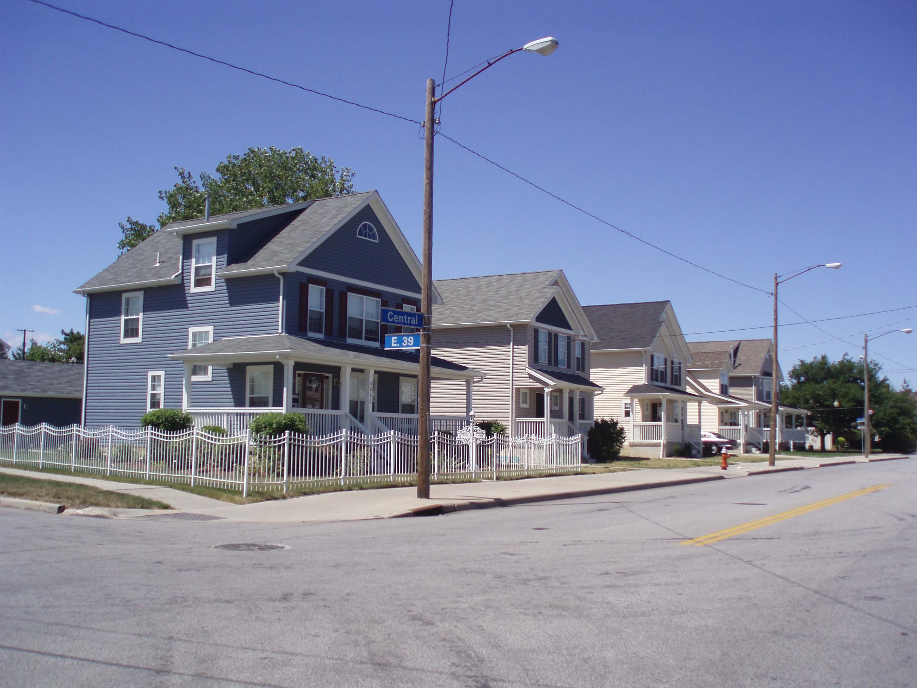